
New Sheet Map of London
New Sheet Map of London is the first to take advantage of the “Free our Data Campaign” and Ordnance Survey’s recent relaxation in licensing policies.
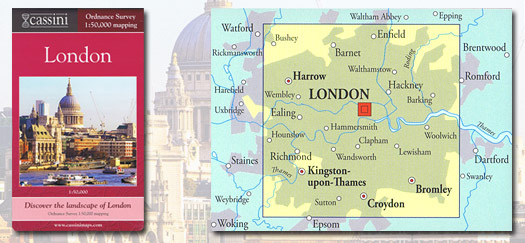
Cassini Maps has launched a new folded sheet map of London using Ordnance Survey data at 1:50,000 scale.
One may initially think, “so what? Another map of London?”
However the story behind this seemingly unremarkable occurrence shows it is rather more than that…
The Ordnance Survey Landrangers at 1:50,000 scale, often referred to as the pink maps (unsurprisingly, due to their distinctive pink covers), have provided the definitive coverage of Great Britain since the 1970s. It’s probably true that a vast proportion of UK households contain one Landranger, somewhere on a shelf or in a rucksack.
These are derived from a seamless digital map of Great Britain that is chopped into manageable 40km x 40km chunks and printed on a series of large sheets – 204, to be exact.
The problem with chopping the country up in this way is that there are going to be towns or cities that fall across a join. Norwich, Swansea, Sheffield and Ordnance Survey’s home city of Southampton all suffer from this problem to some degree. But nowhere suffers as badly as London.
The capital is split across two Landrangers, 176 (West London) and 177 (East London) with a considerable overlap. It’s not known why this seemingly odd decision was taken; but once made, Ordnance Survey did not re-adjust the coverage, despite the fact that the whole of London more or less up to the M25 can be accommodated on one Landranger-size sheet.
This is the problem that Cassini has solved with its new London map using Ordnance Survey 1:50,000 mapping data.
“This problem struck us when we preparing our boxed set of historical Ordnance Survey maps of London in 2007,” Cassini’s Cartographic Director James Anderson recalls. “We’d already spent three years scanning and combining historical maps to match the Landranger sheets and people had to buy twice as many maps as they really needed to cover the whole of London. So, we decided to create a set of historical maps centred on Charing Cross.”
Five such maps of the city having been created, the logical step was to produce a matching present-day one. “Unfortunately,” Anderson recalls, “Ordnance Survey’s licensing policy at that time prohibited anything other than one-off reproduction of this data at larger than A3 size. Somewhat to our surprise, and much to our disappointment, we were therefore unable to proceed. We were convinced there was a demand for this, both as a stand-alone and as part of our London map set; but, as matters stood, nobody but Ordnance Survey could satisfy it. We can’t deny it was frustrating – rather like publishing a book but with the last chapter missing.”
The following years witnessed ever-intensifying discussions between Ordnance Survey, the government, the OFT and various other interested parties to bring these licensing regulations into line with current attitudes and regulations concerning freedom of information, competition and third-party access to public data.
Between April 2010 and May 2011, various far-reaching licensing relaxations were finally announced. One of the many changes was to the 1:50,000 mapping, which could now be produced by other publishers in formats that Ordnance Survey had previously been unwilling to provide.
For the first time since the inception of the Landranger series in the 1970s, a new full-sized sheet map at 1:50,000 was born. The whole city is now available, at a glance and on one sheet – and using the most up-to-date version of the familiar, authoritative Ordnance Survey mapping that has been part of the national consciousness for nearly four decades.
The map has an RRP of £6.99 (zero-rated for VAT) is available from a wide range of retail outlets and on-line at www.cassinimaps.com
ISBN: 9781847368195
-ends-
About Cassini
Cassini Publishing Ltd (Cassini Maps), provides high quality reproductions of Ordnance Survey historical mapping. The company was formed in 2006 with the aim of scanning, preserving and providing web and print access to the UKs national heritage of historical mapping.
As well as producing printed maps that match modern day OS maps for easy comparison (never previously attempted), Cassini provides immediate downloads and prints of many different types of historical OS mapping using Cassini ‘Mapmaker’, an on-line browse-and-search service that allows users to identify easily their area of interest on a historical map – a vital tool for genealogists, researchers and anyone with an interest in the history of their local surroundings.
Cassini Publishing Ltd is based in London and Berkshire and can be contacted viahttp://www.cassinimaps.com, or via e-mail on info@cassinimaps.com or on 0845 230 0952.
