
Monthly Archives: January 2013
Map of the week – Alloway & Burns Night
Reply
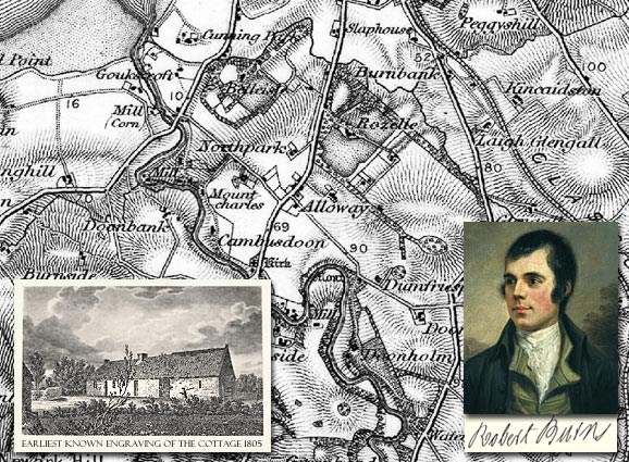
Robert Burns (25 January 1759 – 21 July 1796)
 On this day: On the 25th January 1759, Robert Burns was born in a humble cottage in the village of Alloway, two miles south of Ayr. His parents Willian Burnes (later changed to Burns) and Agnes Broun were tenant farmers, but they ensured their son received a good education and he soon began to read avidly. Burns increasingly turned his attentions away from farming and towards the passions of poetry, nature, drink and women which would characterise the rest of his life
Burns Night, in effect a second national day, is celebrated on Burns’s birthday, 25 January, with Burns suppers around the world. The first Burns supper in The Mother Club in Greenock was held on what was thought to be his birthday on 29 January 1802; in 1803 it was discovered from the Ayr parish records that the correct date was 25 January 1759.
The format of Burns suppers has changed little since. The basic format starts with a general welcome and announcements, followed with the Selkirk Grace. After the grace comes the piping and cutting of the haggis, when Burns’s famous “Address to a Haggis” is read and the haggis is cut open.
| Address to a Haggis (first verse) Fair fa’ your honest, sonsie face, Great chieftain o’ the puddin-race! Aboon them a’ ye tak your place, Painch, tripe, or thairm: Weel are ye wordy o’ a grace As lang’s my arm. |
(sonsie = jolly/cheerful, aboon = above, painch = paunch/stomach, thairm = intestine)
The event usually allows for people to start eating just after the haggis is presented. This is when the reading called the “immortal memory”, an overview of Burns’s life and work, is given. The event usually concludes with the singing of “Auld Lang Syne”.
Map of the week – Rockfield
The use of the English name, Rockfield (near Monmouth), is first documented in 1566. However, it is believed that the name dates back to the 11th century, being derived from the French, Rocheville. The pre-Norman name for the settlement was Llanoronwy.
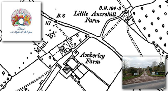
OS 1:2,500 County Series 1887
37 years ago, the band Queen started the New Year as they had left the previous year, at No. 1 with Bohemian Rhapsody. The song was taken from the album A Night at The Opera that had been recorded earlier in 1975.
The song and album were begun at the aptly named Rockfield Studios just outside the village of Rockfield, near Monmouth, and completed at four further recording studios across the country.
Rockfield Studios was started in 1963 by brothers Charles and Kingsley Ward who converted the outbuildings at the family home, Amberley Farm, into the world’s first residential recording studio.
The map shown is from 1887, and forms a small part of Cassini’s huge collection of historical OS maps available for download or as gifts.
The studios continue to maintain their reputation as one of the foremost in the country and have an enviable list of returning musicians. What’s even better is that when not in use by musicians, the cottages are available to rent.
More maps at www.cassinimaps.co.uk
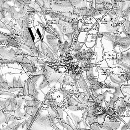
Map of the week – Edgehill
 January 1643
3 months after the first battle of the Civil War, Edgehill, a pamphlet describing the ghostly events that continued in the area after the battle was published. Titled “A Great Wonder in Heaven”, it reported the first encounter with a ghostly re-enactment of the battle by local shepherds. The priest at Kineton also described his brush with the ghosts when around the battlefield. King Charles dispatched a Royal Commission to investigate – they too described a ghostly battle scene, the details tallied with survivors actual accounts of the real battle.
The villagers decided the only way to rid themselves of these phantoms was to bury all the battle-dead in Christian graves (the bodies still remained on the field through the winter).
This map shows the battle area with Grave Ground and Graveground Coppice clearly marked.
To this day, there are still reports of eerie sounds and phantom soldiers appearing at the scene on the anniversary of the battle.
The area has also has a fascinating 20th century military history that can be explored
Maps, Genealogy and Local History
Many people today are interested in genealogy to understand not just where and when people lived, but also their lifestyles, surroundings and motivations. This often requires knowledge of old political boundaries, migration trends and historical social conditions. One important way to understand how one’s ancestors fit into the landscapes of the past is to place them in space and time by using historical mapping.

“My Mother’s grandmother came from Woolbeding, a tiny settlement near Midhurst. I found your map very useful when I went to visit the area because I could trace the original roads unobscured by modern developments. It was great to see the house where my great-grandmother’s twin sister was a dairy maid in 1871 and the tiny church next door still candlelit where they were baptised.” Miss Driscoll, Manchester
Genealogical research is a complex process that uses historical records to answer questions about ones ancestors, the time they lived in, the work they undertook and their surroundings. Reliable conclusions are based on quality sources and historical maps have an important part to play in discovering where and how your ancestors lived.
From the beginnings of Britain’s industrial past to the more sedate life of a victorian country village more detailed can help to put the lives of your ancestors into context. The interest In old maps is constantly growing as more maps become available and the ability to see more and more detail allows the researcher to view ever increasing details of the past.
For example – In the last 200 years Coventry has grown in population from 21,853 in 1801 to 310,500 in 2010. Many of the old outlying towns and villages have been absorbed into the conurbation we see today and the only way of understanding the landscape they used to live in is to view the maps of the time.
 |
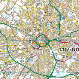 |
| Old Series 1831 | Present Day |
“Old maps of the sort published by Cassini are an excellent introduction to local history throughout the United Kingdom because they focus the user’s attention on the sort of unexpected questions that act as starting points for research. “Well, I never knew that there was a house in that location 200 years ago”. “I never realised that xxxx Road followed a different course 150 years ago . . . why?”. Of course, detailed local histories will probably contain the answers to some of these questions – but they hardly ever force them on you as vividly– and attractively – as old maps. And, in some cases, you will find yourself asking questions that even the standard histories do not answer. So, before consulting those published histories, look at the maps!” Peter Barber MA, FSA, FRHistS Head of Map Collections, British Library
From the beginnings of Britain’s industrial past to the more sedate life of a victorian country village more detailed maps are now available to put the lives of your ancestors into context. The interest In old maps is constantly growing as more maps become available and the ability to see more and more detail allows the researcher to view ever increasing details of the past.
