Free historical map of your home!

Cassini Free Map Offer
Only one map per visit.  Available only while stocks last.

Cassini’s historical printed maps are digitally enhanced reproductions of the original Ordnance Survey maps of the same names – but with a very important difference. We have combined, re-projected and enlarged them to match the scale and coverage of the present-day Ordnance Survey Landrangers®, so making direct comparison between the past and the present easy and accurate.

Get your map from  www.cassinimaps.co.uk/freedeal

Maps are chosen from one of the three Cassini Historical map series:

Old Series MapOld Series Edition
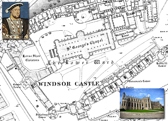
Created from Ordnance Survey Old Series Edition maps first published between 1805 and 1874 These maps were the result of the first ever national survey of England & Wales. From the late 1790s until 1874, a small army of surveyors covered every corner of the what was still an almost entirely rural country. Their work provided a stunning portrait of the landscape, with every farm, track, copse and hamlet recorded. Many of these features would have been unchanged for centuries, reminders of ancient patterns of settlement dating back to Saxon times.

Revised New SeriesRevised New Series (Colour)
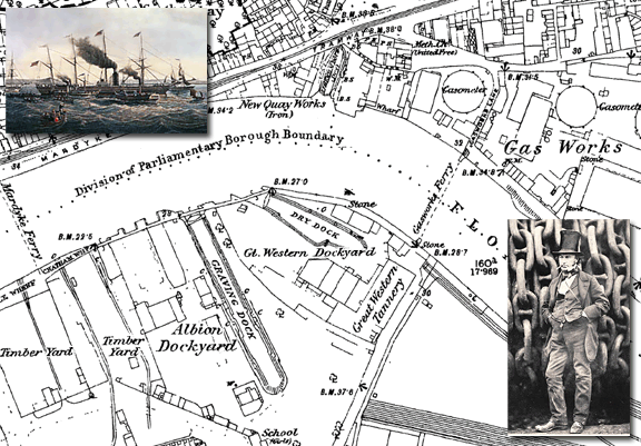
By the late 1890s, the Ordnance Survey had produced two complete series of maps of England & Wales but the increasingly rapid pace of change and development meant that revising them was now a never-ending task. The main cause of this change was the growth of the railways. From being little more than a good idea in 1830, the network covered over 18,000 miles by the end of the century, enabling the spread of goods, people and ideas and changing the character of every place it touched.

Popular Edition
Popular Edition MapThe original Ordnance Survey Popular Edition series was conceived before, but published just after, the First World War. This was the first of Ordnance Survey’s series to be conceived from the outset as a mass-market product, and the first to be produced in full colour. The new technology was put to the test in catering for a wholly new market.
If the railways were the transport revolution of the 19th century, the motor car was certainly that of the 20th.

Get your map from www.cassinimaps.co.uk/freedeal

Some areas have limited stock availability. If the Map of your selected area is not available you will be advised of this on the Website at the time of making your application in which case you may then choose a Map of a different area.

The map of your chosen area will be from one of the three available series.
Unfortunately it is not possible to choose which series your map is from.
The Map is available for delivery in the UK only. £2.99 P&P charges will apply.

SS Great Western & Bristol Docks

Map: Ordnance Survey County Series 1:2500 – 1886
SS Great Western
SS Great Western – the largest vessel in the world.

19th July 1837 – Isambard Kingdom Brunel’s 236 ft steamship, the Great Western, was launched at Bristol. She was the largest vessel in the world. On the same day in 1843, his ‘Great Britain’, the first Atlantic liner built of iron, was launched at Wapping Dock.The Great Western was an iron-strapped, wooden, side-wheel paddle steamer, with four masts to hoist the auxiliary sails. The sails were not just to provide auxiliary propulsion, but also were used in rough seas to keep the ship on an even keel and ensure that both paddle wheels remained in the water, driving the ship in a straight line. The first steamship purpose-built for crossing the Atlantic, and the initial unit of the Great Western Steamship Company. She was the largest passenger ship in the world from 1837 to 1839.

In 1838 after sailing to London, where she was fitted with two side-lever steam engines. the Great Western set sail for Avonmouth to start her maiden voyage to New York. The ship hadn’t gone far when a fire broke out in the engine room. During the confusion Brunel fell 20 feet, and was injured. The fire was extinguished, and the damages to the ship were minimal, but Brunel had to be put ashore at Canvey Island. As a result of the accident, more than 50 passengers cancelled their bookings for the Bristol-New York voyage and when the Great Western finally departed Avonmouth, only 7 passengers were aboard.

The Great western’s first voyage in April 1838 was set to be a race with the British and American Steam Navigation Company’s rival ship the SS Sirius but the fire delayed the Great western’s start. Even with a four-day head start, Sirius only narrowly beat Great Western, arriving in New York on 22 April. When coal ran low, the crew of the Sirius burned 5 drums of resin. The Great Western arrived the following day, with 200 tons of coal still on board. Sirius is often credited as the first winner of the Blue Riband (even though the term Blue Riband was not coined until years later) at 8.03 knots. However, Sirius only held the record for a day because Great Western’s voyage was faster at 8.66 knots.

Still capable of making record Blue Riband voyages as late as 1843. Great Western worked to New York for 8 years until her owners went out of business. She was sold to the Royal Mail Steam Packet Company and was scrapped in 1856 after serving as a troop ship during the Crimean War.

If you have an interesting story and would like to see a historical map of your area then why not let us know by emailing us.

Map of the week – The hottest town and the biggest bang!

Map: Ordnance Survey Old Series 1:50,000 – 1805
Faversham, Kent

Faversham in Kent. The hottest town on record and the biggest bang in history.

As summer looks to have finally arrived we decided to look at Faversham, which holds the record for the highest temperature ever recorded in the UK. A temperature of 38.5C (101.3F) was recorded at the Brogdale Horticultural Trust, on the southern edge of the town, on the 10th August 2003.

Faversham (shown on this map of 1805 as Feversham) is a market town and civil parish in the Swale district of Kent. Faversham is one of the few UK places with a hybrid Latin/Anglo-Saxon name: Favers (Latin faber = blacksmith) + ham (Anglo-Saxon ham = homestead).

The building of Watling Street, soon after the Romans arrived in 43AD, led to the growth of small settlements along-side the road with the first in this area being built at Ospringe. Not long after, the small town of Durolevum (meaning stronghold by the clear stream) was established nearby and grew to become modern day Faversham. In 811AD the name of ‘Fefresham’ was first recorded in a Royal Charter calling it “the king’s town”. Faversham is the only town in the UK to use the Royal arms of England as its own heraldic emblem.
The town also became known as the birthplace of the explosives industry in England. 

The first gunpowder plants were established in the 16th century, The early factories were small, but by the early 18th century these had formed into a single plant, later to be known as the Home Works. A second factory was started by Huguenot settlers towards the end of the 17th century, and became known as the Oare Works. The third and last gunpowder factory to open was the Marsh Works, built by the British government 1 km northwest of the town and opened in 1787.

When the First World War started in 1914, the two original factories were requisitioned by the Admiralty. Production facilities were expanded and many new staff recruited from Faversham and elsewhere in east Kent.

At 2.20pm on Sunday 2 April 1916, a huge explosion ripped through the Marsh Works gunpowder mill, when 200 tons of TNT ignited. The blast killed 105 people and was recorded as “the worst ever in the history of the UK explosives industry”. The munitions factory was in a remote spot in the middle of the open marshes, next to the Thames coastline and was heard across the Thames estuary as far away as Norwich, Great Yarmouth and Southend-on-Sea, where domestic windows were blown out and two large plate-glass shop windows shattered.

All three gunpowder factories closed in 1934. ICI, the then owners, sensed that war might break out with Germany, and realised that Faversham would then become vulnerable to air attacks or possibly invasion. Production was transferred to Ayrshire, Scotland.

If you have an interesting story and would like to see a historical map of your area then why not let us know by emailing us.

Find out more about your area of the UK

Map of the week – St. George’s Chapel, Windsor

Map: Ordnance Survey County Series 1:1,056 – 1871
St George's Chapel, Windsor

 St. George’s Chapel, Windsor – burial place of Henry VIII

Henry Tudor was born in the royal residence of Greenwich Palace on June 28, 1491, son of Henry VII of England and Elizabeth York. Not much is known about his early life because he was not born first in line to the throne, a role destined for his older brother Arthur, but  in 1502, at the age of only 15, Arthur died in Ludlow Castle where he resided in his capacity as Prince of Wales. Arthur’s death thrust all of his royal duties upon his younger brother, the 10-year-old Henry.

Henry was crowned Henry VIII, king of England following the death of his father on 22 April 1509.

Besides his six marriages, Henry VIII is known for his role in the separation of the Church of England from the Roman Catholic Church. His struggles with Rome led to the separation of the Church of England from papal authority, the Dissolution of the Monasteries, and his own establishment as the Supreme Head of the Church of England.

His contemporaries considered Henry in his prime to be an attractive, educated and accomplished king, and he has been described as “one of the most charismatic rulers to sit on the English throne”.
Later in life, Henry became obese, with a waist measurement of 54 inches and his physical decline can be traced to a jousting accident in 1536, in which he suffered a leg wound that never healed as well as head injuries.

Henry died in London on the 28th January 1547  and was buried in St George’s Chapel, Windsor Castle, next to his third wife Jane Seymour, who had given birth to Henry’s only legitimate son, Edward, the future Edward VI. Over a hundred years later, Charles I was buried in the same vault. All three still lie in the vault beneath the quire in St. Georges Chapel, Windsor.

If you have an interesting story and would like to see a historical map of your area then why not let us know by emailing us.

Find out more about your area of the UK