Lions, Vesuvius and a parachuting monkey

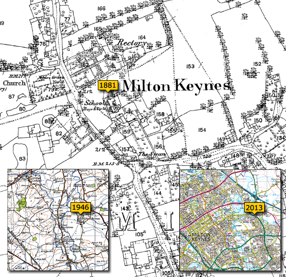
Map: Cassini Maps – Ordnance Survey County Series 1:2500 – 1875
Surrey Zoological Gardens

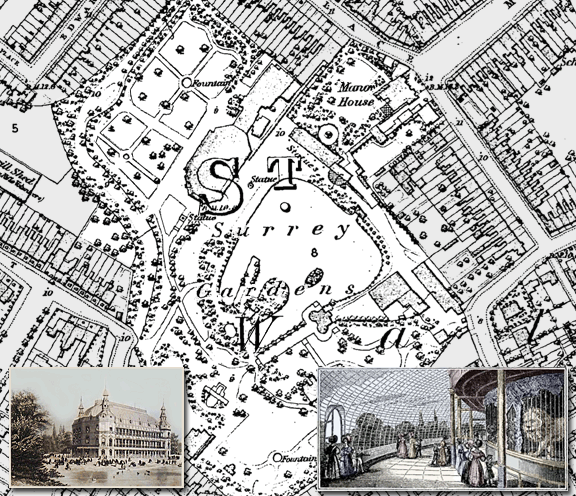
Royal Surrey Gardens – Surrey Zoological Gardens and the Surrey Music Hall

Royal Surrey Gardens were pleasure gardens in Kennington, London opened in 1832, comprising of the Surrey Zoological Gardens and later the Surrey Music Hall. The gardens occupied 15 acres to the east side of Kennington Park Road, including a lake of about 3 acres. The land, originally the grounds of the manor house of Walworth, was acquired by impresario Edward Cross as the location of his new Surrey Zoological Gardens with the aim of competing with the new London Zoo in Regent’s Park.

A large circular domed glass conservatory was built, 300 feet in circumference with more than 6,000 square feet of glass, to contain separate cages for the animals including lions, tigers, a rhinoceros, giraffes and in a female gorilla. At that time it was the largest building of its kind in England. The gardens were also dotted with picturesque pavilions, heavily planted with native and exotic trees and alongside the broad walk Parrots, Maccaws, and Cockatoos sat on perches in the open air.

Other attractions included the leading balloonist in Britain at the time, Charles Green. As balloon flights became more commonplace, the accompanying attractions became more bizarre. Two of Green’s ascents from the Surrey Zoological Gardens on May 26 1835 included him being “ … accompanied by the Celebrated Monkey Jacopo who will Descend in a Parachute!”. Jacopo was credited as “… the Monkey who has seen the World”

From 1837 the gardens were used for large public entertainments such as re-enactments of the eruption of Mount Vesuvius, the Great Fire of London, The Siege of Gibraltar and Napoleon’s passage over the Alps, using large painted sets up to 80 feet (24 m) high, and spectacular firework displays.

By 1856, following the death of Edward Cross and with the intense competition from the Great Exhibition at the Crystal Palace, the animals were sold off and the money used to build Surrey Music Hall, a building capable of holding 12,000 seated spectators, making it the largest venue in London.

Apart from the nightly musical entertainments, religious services were held at the Music Hall at weekends by the famous Baptist preacher, Charles Spurgeon, who at just 25, had established himself as the “most wonderful preacher” in England. The first service was held on the evening of Sunday 19 October 1856 with an audience, estimated at 14,000, crammed inside with many thousands more outside. It was, however, to end in tragedy when someone shouted fire and panic ensued. Seven of the congregation were killed in the crush, and many more injured. Not daunted, Spurgeon returned a few weeks later and the services continued to attract audiences of over 10,000.

Charles Spurgeon moved to new premises in 1859 but the music hall continued until it was destroyed by fire in 1861. The gardens finally closed to the public in 1862.

Find out more about historical maps of your area of the UK

25% OFF All Cassini Historical Maps!

25% Off Cassini historical maps!
To help you enjoy the summer Cassini Historical Maps is offering 25% off all maps and personalised map gifts until the end of August 2013. To get your discount simply use the code C-AUG13 when prompted during checkout.

Visit www.cassinimaps.co.uk now and see which maps we have available for your area. Buy them for yourself or make a present of the past to someone in your life.

Map of the week – Milton Keynes, village, town, city or county?

Main Map: Ordnance Survey County Series 1:2500 – 1881
Milton Keynes

Milton Keynes – the smallest county in the country.

Milton Keynes is a town in Buckinghamshire (*more about that below), about 45 miles north-west of London. It was designated as a new town on 23 January 1967, with the design brief to become a ‘city’ in scale.

The original Village name has gone through many variations over the years. The village was originally known as Middeltone (11th century); then later as Middelton Kaynes or Caynes (13th century); Milton Keynes (15th century); and Milton alias Middelton Gaynes (17th century).

In the census of 1901 the village of Milton Keynes was recorded as having a population of just 219, a far cry from modern day Milton Keynes which population, according to the 2011 census, has risen to a staggering 229,941.

Since the 1950s, overspill housing for several London boroughs had been constructed in Bletchley. Further studies in the 1960s identified north Buckinghamshire as a possible site for a large new town, This new town would be built to encompass the existing towns of Bletchley, Stony Stratford and Wolverton. The New Town (informally, “New City”) was to be the biggest yet, with a target population of 250,000 in a ‘designated area’ of 34.1 sq miles. The name “Milton Keynes” was taken from the existing village of Milton Keynes on the site. The site was deliberately chosen for its location being equidistant from London, Birmingham, Leicester, Oxford and Cambridge.

Milton Keynes Development Corporation planned the major road layout according to street hierarchy principles, using a grid pattern of approximately 1 km (0.62 mi) intervals.

Facinating facts about MK include:

It’s the fastest growing urban area in Europe. There are currently twice as many births as there are deaths and around 13 people a day move to Milton Keynes.
Central Milton Keynes’s shopping centre is in the Guinness Book of Records for being the longest in the World.
Michael Jackson, David Bowie, Queen, U2 and Robbie Williams have all played the Milton Keynes National Bowl.
The Crownhill Estate’s streets are all named after dead celebrities including Presley Way, Hendrix Drive Crosby Court, Keaton Close and Monroe Avenue.

*Three bids to grant Milton Keynes city status have so far been submitted to the Government but none have succeeded, but that could be because a little known piece of legislation in 1995 actually names Milton Keynes as a county. The legislation reads ‘Milton Keynes shall cease to form part of Buckinghamshire’ and ‘a new county shall be constituted comprising the area of Milton Keynes and shall be named the county of Milton Keynes’. This new county includes all areas covered by Milton Keynes Council, including locations such as Olney, Newport Pagnell and Stony Stratford. 

With an area of around 119 square miles it makes Milton Keynes smaller than Rutland, traditionally known to be the smallest county in the country at a relatively massive 147 square miles.

If you have an interesting story and would like to see a historical map of your area then why not let us know by emailing us.

Cassini has historical maps of England, Scotland, Wales and Ireland going back 200 years. Visit Cassini Maps to discover the landscape of your past