Old Parish Maps – Reduced to £5.99

Cassini Old Parish Map

One week Special Offer RRP £12.99 – Now only £5.99
Offer ends 16th Feb 2015

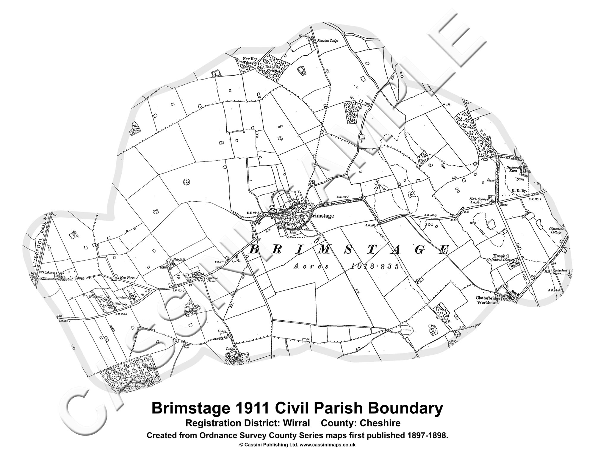
Cassini Maps has created 14,659 individual historical Parishes Maps, which form an essential resource for local history researchers, genealogists and historians. As parish boundaries have changed over time, its essential to know where your ancestors lived and to understand the landscape that shaped their lives.

• Parish Maps provide a direct link to Census and Parish Records.
• Download the PDF to view on screen and print at home.
• Parish boundaries as they were in 1911.
• Detailed Ordnance Survey mapping published between 1880 – 1910.
• Downloadable PDFs of English and Welsh Parishes.
• Scale: Street-level mapping – 1:10,000 (originally 1:10,560).

(Sample)  (Keys & Legends)

14,659 individual historical Parishes Maps are now available to download and to print at home. These maps provide a vital link to Parish Records and show in great detail the historical Parishes in which your ancestors lived and worked. Each maps is taken from the Ordnance Survey County Series 1:10,560 maps from the cusp of 19th and 20th centuries and show the Historical Parish Boundary as recorded at the time of the 1911 census.

To buy your Old Parish Maps please visit Cassini Maps

Historical Map downloads of Ireland – Half Price!

Cassini’s Irish downloadable maps from the mid to late 1800’s.
Cassini Historical Mapping of Ireland

From only £4.49! One week only. Offer available until 16th Feb 2015

• Instant map downloads of any area.    • Including personal inscription.
• Available for 3 historical OS series.     • Highly customisable.

Cassini is delighted to offer you our stunning range of historical Ordnance Survey maps of Ireland. Simply search for the area you are interested in, buy and download the PDF.

Whatever your interest in the past our historical maps are invaluable works of reference. Ideal for research, or print and frame for a personalised decorative map centred on the location of your choice.

Irish 6 Inch First Edition Downloads –  c. 1840’s
Ireland First Edition Downloads – c. 1860’s
Ireland Third Edition Downloads – c. 1900’s

Visit Cassini and find maps of Ireland.

Historical Map Downloads – Half price!

Cassini Downloadable maps
Warnborough - 1871. 1:2,500

From only £3.99 – One week only. Offer finishes on the 16th February 2015
Coverage – England, Scotland, Wales.
Ideal for research, or print and frame for a personalised decorative map centred on the location of your choice. A4 maps £3.99, A3 maps £4.99

Cassini’s downloadable maps from 1805 to the present day.

• Instant map downloads of any area.  • Including personal inscription.
• Available for all historical OS series. • Choose from eight historical map series
• Highly customisable.                          • Coverage of England, Scotland* and Wales.

Cassini is delighted to offer you our stunning range of historical Ordnance Survey maps. Whatever your interest in the past our historical maps are invaluable works of reference. Ideal for reasearch, or print and frame for a personalised decorative map centred on the location of your choice.

Simply search for the area you are interested in, buy and download the PDF. No waiting for the map to arrive in the post.

Maps available for site-centred downloads
1855-1896 County Series 1:2,500
1880-1910 County Series 1:10,000
1805-1874 Old Series 1:30,000 – 1:50,000
1871 Registration District 1:30,000 – 1:50,000
1896-1904 Revised New 1:30,000 – 1:50,000
1919-1926 Popular Edition 1:30,000 – 1:50,000
1945-1948 New Popular 1:30,000 – 1:50,000
Present Day Ordnance Survey 1:30,000 – 1:50,000

*Scottish maps are only available for Old Series 1805-1874, Revised New Series 1896-1904 and Presentr Day OS mapping.

Visit Cassini Maps to find maps of your area.