Old Parish Maps – Reduced to £5.99

Cassini Old Parish Map

One week Special Offer RRP £12.99 – Now only £5.99
Offer ends 16th Feb 2015

Cassini Maps has created 14,659 individual historical Parishes Maps, which form an essential resource for local history researchers, genealogists and historians. As parish boundaries have changed over time, its essential to know where your ancestors lived and to understand the landscape that shaped their lives.

• Parish Maps provide a direct link to Census and Parish Records.
• Download the PDF to view on screen and print at home.
• Parish boundaries as they were in 1911.
• Detailed Ordnance Survey mapping published between 1880 – 1910.
• Downloadable PDFs of English and Welsh Parishes.
• Scale: Street-level mapping – 1:10,000 (originally 1:10,560).

(Sample)  (Keys & Legends)

14,659 individual historical Parishes Maps are now available to download and to print at home. These maps provide a vital link to Parish Records and show in great detail the historical Parishes in which your ancestors lived and worked. Each maps is taken from the Ordnance Survey County Series 1:10,560 maps from the cusp of 19th and 20th centuries and show the Historical Parish Boundary as recorded at the time of the 1911 census.

To buy your Old Parish Maps please visit Cassini Maps

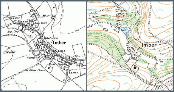
Map of the month – The lost village of Imber

Lost Village of Imber

The lost village of Imber, Wiltshire (County series 1:10,000)

Described by Ella Noyes in the 1890’s, Imber was “one straggling street of old cottages and farmsteads winding along the hollow under the sheltering elms.” The village of Imber had been a remote village nestled in a small valley on Salisbury Plain in Wiltshire. It had for centuries made the most of its secluded existence by surviving largely unscathed by both civil unrest and pestilence that had from time to time existed elsewhere in England.

It was later in the 1890’s that its fortunes started to change with the arrival of the Army on Salisbury Plain. The War Office concluded its search for a large training environment with the purchase of over 40,000 acres of land on the east of the plain.

With the advent of WW1, training increased significantly around Imber with the villagers suffering virtual imprisonment as the surrounding countryside was shelled.

The village struggled to maintain its self-sufficiency on the cratered landscape it had sought to farm in the post war years and its decline continued until 1943, when, with the village now in the centre of the military’s western ranges, the inhabitants were given 46 days to leave.

There is little of the original village remaining today and nearly half of the standing structures were built by the army.

If you have an interesting story and would like to see a historical map of your area then why not let us know by emailing us.