When is a railway not a railway?

Surry_Iron_Railway

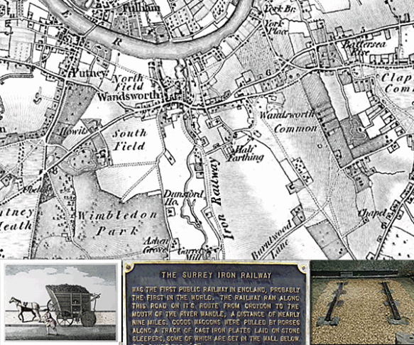
The Surrey Iron Railway, Wandsworth, London: Ordnance Survey Old Series 1805

The Surrey Iron Railway (SIR) was first public railway independent of a canal to be built by Act of Parliament (1801).

Although private railways were already in operation around Britain these were used exclusively by the owners of mines and quarries for moving their own goods. The SIR was different, it levied Tolls allowing independent goods hauliers to use their own wagons (with wheels at a suitable distance apart) pulled by horses.

Opened in 1803 it ran for approximately nine miles along the side of the River Wandle from Wandsworth Wharf, on the River Thames, towards Mitcham and Croydon

The Surrey Iron Railway is famous for being the first company in the world to include the word “railway” in it’s title.  Despite this it was not what we today would recognise as a railway.  It was actually a plateway, where vehicles with plain wheels ran along flanged rails.

The track comprised iron L-section rails 4ft 2in (1.27m) apart secured onto stone blocks. The trucks were horse-drawn, typically 8ft x 4ft x 2ft deep and weighing about 1 tonne. They could carry 3 tonnes of coal, lime or grain. One horse could pull up to ten wagons but the usual number was about four.

The original plan for a transport connection between Wandsworth, on the River Thames, and the Wandle Valley had been for a canal, but doubts about the availability of water led to the adoption of a plateway.

The railway was only briefly successful financially. It lost much traffic after the Croydon Canal opened in 1809 and continued to decline as steam railways took hold. The advent of faster and more powerful steam locomotives spelled the end for horse-drawn railways. In 1823, William James, a shareholder in the railway, tried to persuade George Stephenson to supply a locomotive. Stephenson realised that the cast-iron plateway could not support the weight of a locomotive and declined and railway was finally closed to traffic on 31st August 1846.

Find out more about your area

Moreton. More to Chew on!

Chew Valley

Moreton, Chew Valley, Somerset (OS County Series 1:2,500 – Published 1885-1886)

Chew Valley Lake is a large reservoir in the Chew Valley, Somerset, England, and the fifth-largest artificial lake in the United Kingdom, with an area of 1,200 acres (4.9 km²). The lake, created in the early 1950s and opened by Queen Elizabeth II in 1956, provides much of the drinking water for the city of Bristol and surrounding area.

Under the waters of Chew Lake lies the small hamlet of Moreton. It was mentioned in the Domesday Book and, at the time of its drowning, included a mediaeval chapel, a moated house and a mill. Roman buildings and flints were also found on the site.

Before the lake was created, archaeological investigations were carried out that showed evidence of occupation since Neolithic times and finds of Roman artefacts. Excavations found evidence of a thriving community in medieval times and what is reportedly the remains of the Nunnery of Santa Cruz.  Moreton was also the site of gunpowder mill in the 18th century.

Prior to the flooding of the reservoir excavations of the surrounding area were carried out. The excavations found evidence of habitation dating from the Old, Middle and New Stone Age, Bronze Age and Iron Age. Evidence included implements such as stone knives, flint blades and the head of a mace, along with buildings and graves.

What evidence is left of the area of Moreton today? The historical maps are now the only way to view the details of the landscape and understand the generations of occupation of Chew Valley.

Find out about the history of your area. Visit Cassini Maps

Old Parish Maps – Reduced to £5.99

Cassini Old Parish Map

One week Special Offer RRP £12.99 – Now only £5.99
Offer ends 16th Feb 2015

Cassini Maps has created 14,659 individual historical Parishes Maps, which form an essential resource for local history researchers, genealogists and historians. As parish boundaries have changed over time, its essential to know where your ancestors lived and to understand the landscape that shaped their lives.

• Parish Maps provide a direct link to Census and Parish Records.
• Download the PDF to view on screen and print at home.
• Parish boundaries as they were in 1911.
• Detailed Ordnance Survey mapping published between 1880 – 1910.
• Downloadable PDFs of English and Welsh Parishes.
• Scale: Street-level mapping – 1:10,000 (originally 1:10,560).

(Sample)  (Keys & Legends)

14,659 individual historical Parishes Maps are now available to download and to print at home. These maps provide a vital link to Parish Records and show in great detail the historical Parishes in which your ancestors lived and worked. Each maps is taken from the Ordnance Survey County Series 1:10,560 maps from the cusp of 19th and 20th centuries and show the Historical Parish Boundary as recorded at the time of the 1911 census.

To buy your Old Parish Maps please visit Cassini Maps

Historical Map Downloads – Half price!

Cassini Downloadable maps
Warnborough - 1871. 1:2,500

From only £3.99 – One week only. Offer finishes on the 16th February 2015
Coverage – England, Scotland, Wales.
Ideal for research, or print and frame for a personalised decorative map centred on the location of your choice. A4 maps £3.99, A3 maps £4.99

Cassini’s downloadable maps from 1805 to the present day.

• Instant map downloads of any area.  • Including personal inscription.
• Available for all historical OS series. • Choose from eight historical map series
• Highly customisable.                          • Coverage of England, Scotland* and Wales.

Cassini is delighted to offer you our stunning range of historical Ordnance Survey maps. Whatever your interest in the past our historical maps are invaluable works of reference. Ideal for reasearch, or print and frame for a personalised decorative map centred on the location of your choice.

Simply search for the area you are interested in, buy and download the PDF. No waiting for the map to arrive in the post.

Maps available for site-centred downloads
1855-1896 County Series 1:2,500
1880-1910 County Series 1:10,000
1805-1874 Old Series 1:30,000 – 1:50,000
1871 Registration District 1:30,000 – 1:50,000
1896-1904 Revised New 1:30,000 – 1:50,000
1919-1926 Popular Edition 1:30,000 – 1:50,000
1945-1948 New Popular 1:30,000 – 1:50,000
Present Day Ordnance Survey 1:30,000 – 1:50,000

*Scottish maps are only available for Old Series 1805-1874, Revised New Series 1896-1904 and Presentr Day OS mapping.

Visit Cassini Maps to find maps of your area.

Map of the month – Old Sarum. 3 houses, 7 voters and 2 MPs

Old Sarum  –  Map: County Series 1:2500 1881
Old Sarum & Rotten Boroughs

Old Sarum, in Wiltshire, was  a parliamentary constituency in England from 1295 to 1832. The constituency was on the site of what had been the original settlement of Salisbury, known as Old Sarum.

It was a so-called ‘rotten borough’ (or ‘pocket borough’) with an extremely small electorate that was consequently vastly over-represented and could be used by a patron to gain undue influence. Rotten boroughs were one of the curiosities of the British electoral system, where fathers passed on constituencies (and the power as an MP that went with this) to their sons as if they were personal property. In many such boroughs the very few electors could not vote for whom they truly wanted due to the lack of a secret ballot or simply due to the lack of a candidate desirable to their political philosophy. The term rotten borough came into use in the 18th century. The word “rotten” had the connotation of corruption as well as that of long-term decline.

Rotten boroughs had very few voters. For example, Old Sarum, in Wiltshire, only had three houses and a population of seven people. It was a possession of the Pitt family from the mid-17th century to 1802, and one of its Members of Parliament was Prime Minister William Pitt the Elder. In 1802 the Pitt family sold it for £60,000, even though the land and manorial rights were worth £700 a year at most.

Examples of rotten boroughs in 1831 include the following:

Borough Patron MPs Returned Houses in Borough Voters in 1831
Old Sarum, Wiltshire Earl of Caledon 2 3 7
Gatton, Surrey Sir Mark Wood 2 23 7
Bramber, West Sussex Duke of Rutland 2 35 20
Newton, Isle of Wight Sir Fitzwilliam Barrington 2 14 23
Dunwich, Suffolk Lord Huntingfield 2 44 32

With just a few individuals with the vote and no secret ballot, it was easy for candidates to buy their way to victory.

The constituency of Old Sarum was abolished under the Reform Act 1832

Indications of prehistoric settlement at Old Sarum have been discovered from as early as 3000 bc. An was erected around 400 bc, The site continued to be occupied during the Roman period. The Saxons took the British fort in the 6th century and later used it as a stronghold against marauding Vikings. Later the Normans constructed a motte and bailey castle, a stone curtain wall, and a great cathedral. A royal palace was built within the castle for King Henry I and was subsequently used by Plantagenet monarchs. This heyday of the settlement lasted for around 300 years. By the early 13th century the population had moved to New Sarum at the foot of the hill, now known as the cathedral city of Salisbury and the long neglected castle was finally abandoned by Edward II in 1322.

To buy this map, or maps of your area, go to:  Cassini Downloads
Simply enter a postcode, or place name, follow the instruction and download your map in minutes.