When is a railway not a railway?

Surry_Iron_Railway

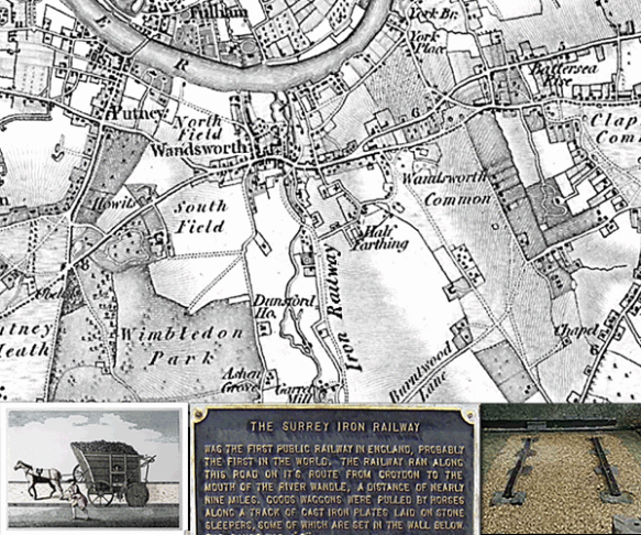
The Surrey Iron Railway, Wandsworth, London: Ordnance Survey Old Series 1805

The Surrey Iron Railway (SIR) was first public railway independent of a canal to be built by Act of Parliament (1801).

Although private railways were already in operation around Britain these were used exclusively by the owners of mines and quarries for moving their own goods. The SIR was different, it levied Tolls allowing independent goods hauliers to use their own wagons (with wheels at a suitable distance apart) pulled by horses.

Opened in 1803 it ran for approximately nine miles along the side of the River Wandle from Wandsworth Wharf, on the River Thames, towards Mitcham and Croydon

The Surrey Iron Railway is famous for being the first company in the world to include the word “railway” in it’s title.  Despite this it was not what we today would recognise as a railway.  It was actually a plateway, where vehicles with plain wheels ran along flanged rails.

The track comprised iron L-section rails 4ft 2in (1.27m) apart secured onto stone blocks. The trucks were horse-drawn, typically 8ft x 4ft x 2ft deep and weighing about 1 tonne. They could carry 3 tonnes of coal, lime or grain. One horse could pull up to ten wagons but the usual number was about four.

The original plan for a transport connection between Wandsworth, on the River Thames, and the Wandle Valley had been for a canal, but doubts about the availability of water led to the adoption of a plateway.

The railway was only briefly successful financially. It lost much traffic after the Croydon Canal opened in 1809 and continued to decline as steam railways took hold. The advent of faster and more powerful steam locomotives spelled the end for horse-drawn railways. In 1823, William James, a shareholder in the railway, tried to persuade George Stephenson to supply a locomotive. Stephenson realised that the cast-iron plateway could not support the weight of a locomotive and declined and railway was finally closed to traffic on 31st August 1846.

Find out more about your area

Shakespear’s birthplace

shakespear2

Shakespear’s birthplace, Henley Street.  (MAP: 1886 – Town Plan, Scale: 1:500)

Shakespeare’s Birthplace is a 16th-century half-timbered house situated in Henley Street, Stratford-upon-Avon, Warwickshire, where it is believed that William Shakespeare was born in 1564 and spent his childhood years. Shakespeare is also known to have spent the first five years of married life in this house with his new wife, Anne Hathaway.

The house itself is relatively simple, but for the late 16th century it would have been considered quite a substantial dwelling. John Shakespeare, William’s father, was a glove maker and wool dealer, and the house was originally divided in two parts to allow him to carry out his business from the same premises.

The building is typical of the times and was constructed in wattle and daub around a wooden frame. Local oak from the Forest of Arden and blue-grey stone from Wilmcote were used in its construction, while the large fireplaces were made from an unusual combination of early brick and stone, and the ground-floor level has stone-flagged floors.

The plan of the building was originally a simple rectangle. From north-west to south-east, the ground-floor consisted of a parlour with fireplace, an adjoining hall with a large open hearth, a cross passage, and finally a room which probably served as John Shakespeare’s workshop. A separate single-bay house, now known as Joan Hart’s Cottage, was later built onto the north-west end of the house, and the present kitchen was added at the rear with a chamber above it.

The ownership of the premises passed to William on John Shakespeare’s death.

William already owned his own property in Stratford and had no need for the Henley Street premises as a home for himself or his family. Consequently, the main house was leased to Lewis Hiccox, who converted it into an inn known as the Maidenhead (later the Swan and Maidenhead Inn).

Under the terms of Shakespeare’s will, the ownership of the whole property (the inn and Joan Hart’s cottage) passed to his elder daughter, Susanna, upon his death.

In 1649 it passed to her only child, Elizabeth, and then in 1670 to Thomas Hart. Hart was the descendant of Shakespeare’s sister, Joan, whose family had continued as tenants of the smaller house after her death in 1646. The entire property remained in the ownership of the Harts until 1806.

Find out about the history of your area. Visit Cassini Maps

Moreton. More to Chew on!

Chew Valley

Moreton, Chew Valley, Somerset (OS County Series 1:2,500 – Published 1885-1886)

Chew Valley Lake is a large reservoir in the Chew Valley, Somerset, England, and the fifth-largest artificial lake in the United Kingdom, with an area of 1,200 acres (4.9 km²). The lake, created in the early 1950s and opened by Queen Elizabeth II in 1956, provides much of the drinking water for the city of Bristol and surrounding area.

Under the waters of Chew Lake lies the small hamlet of Moreton. It was mentioned in the Domesday Book and, at the time of its drowning, included a mediaeval chapel, a moated house and a mill. Roman buildings and flints were also found on the site.

Before the lake was created, archaeological investigations were carried out that showed evidence of occupation since Neolithic times and finds of Roman artefacts. Excavations found evidence of a thriving community in medieval times and what is reportedly the remains of the Nunnery of Santa Cruz.  Moreton was also the site of gunpowder mill in the 18th century.

Prior to the flooding of the reservoir excavations of the surrounding area were carried out. The excavations found evidence of habitation dating from the Old, Middle and New Stone Age, Bronze Age and Iron Age. Evidence included implements such as stone knives, flint blades and the head of a mace, along with buildings and graves.

What evidence is left of the area of Moreton today? The historical maps are now the only way to view the details of the landscape and understand the generations of occupation of Chew Valley.

Find out about the history of your area. Visit Cassini Maps

A Race Track, an Airfield and Maggots

Silverstone (MAP: OS Old Series 1:50,000 – published in 1835)
Silverstone
Silverstone is a village and civil parish in Northamptonshire. The village is listed in the Domesday Book.

Silverstone is also the current home of the British Grand Prix, which it first hosted in 1948. The circuit itself straddles the Northamptonshire and Buckinghamshire border, with the current main circuit entry on the Buckinghamshire side and built on the remains of a WWII RAF base.

Even being at the forefront of technical innovation Silverstone has its roots firmly in the landscape’s past. All the corners of the racing circuit have names, many relating to the local area, as shown on the map.

• The first corner on the circuit is Abbey. Named after Luffield Abbey, which occupied the centre of the site from the twelfth century until its Dissolution in 1551 when the land was passed to Sir Francis Throckmorton.
• The second, Farm Curve, simply takes it’s name from a nearby farm.
• The third and fourth corners have literal names in Village, named after Silverstone Village and The Loop, the only corner to be named after it’s shape.
• Then there is Aintree, named after the Aintree course, where the Grand Prix alternated with Silverstone in the late 1950’s to early 1960’s.
• Followed by the Wellington Straight, only named in 2010, which takes it’s name from the Wellington Bombers which flew from RAF Silverstone during WWII.
• Next comes Brooklands, named in honour of the Brooklands Motor Circuit, known as the home of British motor racing.
• Luffield, like the first corner is named after the medieval Abbey.
• Woodecote, like Brooklands, was named in honour of an existing circuit, namely the RAC owned Woodcote Park in Surrey.
• Copse corner is named after the nearby Chapel Copse and Cheese Copse that border the track.
• The oddly named Maggotts actually takes its name from the adjacent Maggots Moor (written with only the one ‘t’ on the map).
• Becketts and Chapel Curve both take their names from the medieval chapel of St Thomas à Beckett which stood near the track features.
• Like the Wellington Straight, Hangar Straight takes it’s name from the time of the RAF base. Two of the largest hangars stood in this area.
• The next corner Stowe takes it’s name from the local area of Stowe, to the south of the track, famous for Stowe School.
• Vale. Although the track is predominantly flat, this is the only undulating area on the track and the probable source of the name. Another theory is that is named after the district of Aylesbury Vale, in which it sits.
• The final corner Club is, like Woodecote, named after the famous RAC club in Pall Mall London.

This weekend sees Silverstone hosing the British Grand Prix with nearly 300,000 people expected to attend. A far cry from the quiet landscape shown on the above 1835 map.

Find out about the history of your area. Visit Cassini Maps


Map of the month – Tunnels and a World Changer.

Welbeck Abbey  (MAP: OS County Series 1:2500 – published in 1886)
Welbeck Abbey

Welbeck Abbey in North Nottinghamshire was the site of a monastery which, after the Dissolution of the Monasteries, became the country house residence of the Dukes of Portland.

William Cavendish-Scott-Bentinck (1800-79), the 5th Duke of Portland, built a 10km-long network of underground corridors on his Welbeck Abbey estate in part of Sherwood Forest.

Cavendish-Scott-Bentinck instructed his builders to construct pathways under the 69sq km of landscaped grounds. Tunnel No. 1 was about 500m long, wide enough for two carriages and had gas lamps installed overhead and led to a 2km pathway connecting the lodge and the south lodge, where the duke’s carriage was kept. The 910m-long Plant Corridor ran between the main house and riding house and was wide enough for several people to walk side by side. Running parallel to the Plant Corridor was a longer, narrower, rougher-hewn tunnel, which the duke had built for the servants, to ensure they never met.

There are many smaller tunnels including a grotto corridor and corridors with narrow-gauge rails on which warm food could be brought on trolleys to the main house. The Horse Corridor leads to an underground ballroom, the largest private room in England at the time – 50m long and 20m high. All these projects were funded by the duke’s properties in London around Portland Square and other properties in the West End.

Many rumours surround the eccentric 5th Duke. He is said to have spent most of his life in a small five-room suite within Welbeck and that he required that a fresh roasted chicken was available at any time, day or night. On the few occasions he left his house to walk in the extensive park, it was only at night and accompanied by a servant, who carried a lantern 30m in front of him and he was observed to only leave the house concealed under an umbrella, two large overcoats, a two foot high top hat, and a double ruff – even in fine weather.

In 1913, Archduke Franz Ferdinand accepted an invitation from the 6th Duke of Portland to stay at Welbeck Abbey and arrived with his wife, Sophie, by train at Worksop on the 22nd November. This was almost a year before his assassination, which triggered off the First World War.

The Archduke narrowly avoided being killed in a hunting accident during his stay. The Duke of Portland was out shooting pheasants with Franz Ferdinand when: “One of the loaders fell down. This caused both barrels of the gun he was carrying to be discharged, the shot passing within a few feet of the archduke and myself. I have often wondered whether the Great War might not have been averted, or at least postponed, had the archduke met his death then and not at Sarajevo the following year.”

Find out about the history of your area. Visit Cassini Maps


Historical Map Downloads – Half price!

Cassini Downloadable maps
Warnborough - 1871. 1:2,500

From only £3.99 – One week only. Offer finishes on the 16th February 2015
Coverage – England, Scotland, Wales.
Ideal for research, or print and frame for a personalised decorative map centred on the location of your choice. A4 maps £3.99, A3 maps £4.99

Cassini’s downloadable maps from 1805 to the present day.

• Instant map downloads of any area.  • Including personal inscription.
• Available for all historical OS series. • Choose from eight historical map series
• Highly customisable.                          • Coverage of England, Scotland* and Wales.

Cassini is delighted to offer you our stunning range of historical Ordnance Survey maps. Whatever your interest in the past our historical maps are invaluable works of reference. Ideal for reasearch, or print and frame for a personalised decorative map centred on the location of your choice.

Simply search for the area you are interested in, buy and download the PDF. No waiting for the map to arrive in the post.

Maps available for site-centred downloads
1855-1896 County Series 1:2,500
1880-1910 County Series 1:10,000
1805-1874 Old Series 1:30,000 – 1:50,000
1871 Registration District 1:30,000 – 1:50,000
1896-1904 Revised New 1:30,000 – 1:50,000
1919-1926 Popular Edition 1:30,000 – 1:50,000
1945-1948 New Popular 1:30,000 – 1:50,000
Present Day Ordnance Survey 1:30,000 – 1:50,000

*Scottish maps are only available for Old Series 1805-1874, Revised New Series 1896-1904 and Presentr Day OS mapping.

Visit Cassini Maps to find maps of your area.

Map of the month – Old Sarum. 3 houses, 7 voters and 2 MPs

Old Sarum  –  Map: County Series 1:2500 1881
Old Sarum & Rotten Boroughs

Old Sarum, in Wiltshire, was  a parliamentary constituency in England from 1295 to 1832. The constituency was on the site of what had been the original settlement of Salisbury, known as Old Sarum.

It was a so-called ‘rotten borough’ (or ‘pocket borough’) with an extremely small electorate that was consequently vastly over-represented and could be used by a patron to gain undue influence. Rotten boroughs were one of the curiosities of the British electoral system, where fathers passed on constituencies (and the power as an MP that went with this) to their sons as if they were personal property. In many such boroughs the very few electors could not vote for whom they truly wanted due to the lack of a secret ballot or simply due to the lack of a candidate desirable to their political philosophy. The term rotten borough came into use in the 18th century. The word “rotten” had the connotation of corruption as well as that of long-term decline.

Rotten boroughs had very few voters. For example, Old Sarum, in Wiltshire, only had three houses and a population of seven people. It was a possession of the Pitt family from the mid-17th century to 1802, and one of its Members of Parliament was Prime Minister William Pitt the Elder. In 1802 the Pitt family sold it for £60,000, even though the land and manorial rights were worth £700 a year at most.

Examples of rotten boroughs in 1831 include the following:

Borough Patron MPs Returned Houses in Borough Voters in 1831
Old Sarum, Wiltshire Earl of Caledon 2 3 7
Gatton, Surrey Sir Mark Wood 2 23 7
Bramber, West Sussex Duke of Rutland 2 35 20
Newton, Isle of Wight Sir Fitzwilliam Barrington 2 14 23
Dunwich, Suffolk Lord Huntingfield 2 44 32

With just a few individuals with the vote and no secret ballot, it was easy for candidates to buy their way to victory.

The constituency of Old Sarum was abolished under the Reform Act 1832

Indications of prehistoric settlement at Old Sarum have been discovered from as early as 3000 bc. An was erected around 400 bc, The site continued to be occupied during the Roman period. The Saxons took the British fort in the 6th century and later used it as a stronghold against marauding Vikings. Later the Normans constructed a motte and bailey castle, a stone curtain wall, and a great cathedral. A royal palace was built within the castle for King Henry I and was subsequently used by Plantagenet monarchs. This heyday of the settlement lasted for around 300 years. By the early 13th century the population had moved to New Sarum at the foot of the hill, now known as the cathedral city of Salisbury and the long neglected castle was finally abandoned by Edward II in 1322.

To buy this map, or maps of your area, go to:  Cassini Downloads
Simply enter a postcode, or place name, follow the instruction and download your map in minutes.

Map of the month – 150 years of the Clifton Suspension Bridge

Clifton Suspension Bridge – County Series 1:2500 1886-1896

Clifton Suspension Bridge
150 years ago today on the 8th December 1864, the Clifton Suspension Bridge had its grand opening. The bridge spans the Avon Gorge and the River Avon, linking Clifton in Bristol to Leigh Woods in North Somerset. The bridge is built to a design by William Henry Barlow and John Hawkshaw, based on an earlier design by Isambard Kingdom Brunel.

In 1753 Bristolian merchant William Vick had left a bequest in his will of £1,000 (equivalent to £130,000 in 2014), invested with instructions that when the interest had accumulated to £10,000 (£1,330,000), it should be used for the purpose of building a stone bridge between Clifton Down.

By 1829, Vick’s bequest had reached £8,000, but it was estimated that a stone bridge would cost over ten times that. A competion was held to find a design, but all the designs, including a final one by Thomas Telford failed to gain aproval because of either looks or cost.

An Act of Parliament was then passed to allow a wrought iron suspension bridge to be built instead of stone, and tolls levied to recoup the cost. In 1831 a second competition was held with new judges. The winner was declared to be a design by Smith and Hawkes of the Eagle Foundry in Birmingham. Brunel then had a personal meeting and persuaded him to change the decision, The committee then declared Brunel the winner and he was awarded a contract as project engineer with his design being finalised by William Henry Barlow and John Hawkshaw . The winning design was for a suspension bridge.

Folklore says that a rope was taken across the gorge by kite, or even by bow and arrow! The simple and much more likely event was that common hemp ropes were taken down the side of the gorge, across the river by boat and pulled up the other side.

The towers are built principally of local Pennant stone. The chains and suspension rods are made of wrought iron with the chains anchored in tapering tunnels, 25 metres (82 ft) long, on either side of the bridge. After completion of the chains, vertical suspension rods were hung from the links in the chains and large girders hung from these. The girders on either side then support the deck, which is 3 feet higher at the Clifton end than at Leigh Wood. The construction work was completed in 1864 — 111 years after a bridge at the site was first planned.

to buy this map or maps of your area go to Cassini Maps

Map of the month – Blackpool before the tower 1891

Blackpool

Blackpool (Ordnance Survey County Series 1:1,056 – Surveyed  C.1891, published in 1893)

For centuries Blackpool was a small hamlet by the sea. Its name stems from a historic drainage channel that ran over a peat bog, discharging discoloured water into the Irish Sea, which formed a black pool (on the other side of the sea, the name “Dublin” (Dubh Linn) is derived from the Irish for “black pool”).

By the middle of the 18th century, the practice of bathing in the sea to cure diseases was becoming fashionable among the wealthier classes, and visitors began making the trek to Blackpool for that purpose. The 1801 census records the town’s population at only 473, but by 1851 the population had risen to over 2,500.  However, Blackpool only grew into a substantial town when the railway was built connecting it to the industrial towns of the north. The first railway in the area opened in 1840 but it only ran as far as Poulton. In 1846 a branch line was built from Poulton to Blackpool, making it much easier and cheaper for visitors to reach the coast.

Blackpool Tower was built between 1891 and 1894, but before the tower visitors flocked to Dr. Cocker’s Aquarium, Aviary and Menagerie, which had existed on the site since 1873. It was kept open to earn revenue while the tower building went up around it, and then became one of the tower’s major attractions. It housed 57 different species of fresh water and salt water fish and the largest tank held 32,000 litres of salt water. The menagerie and aviary, one of the finest collections in the country, included lions, tigers, and polar bears.

The Blackpool Tower Company bought the Aquarium on Central Promenade in 1890 with the intention of building a replica Eiffel Tower on the site. Two Lancashire architects, James Maxwell and Charles Tuke, designed the Tower and oversaw the laying of its foundation stone, on 29 September 1891

When the tower opened on 14 May 1894, 3,000 customers took the first rides to the top. Tourists paid sixpence for admission, sixpence more for a ride in the lifts to the top (the option was 563 steps from the roof of the tower building to the flagpole at the top) and a further sixpence for entry to the circus.

The Tower Circus, which is positioned at the base of the tower between its four legs, first opened to the public on 14 May 1894 and has not missed a season since. The circus ring can be lowered into a pool of water that holds 42,000 gallons at a depth of up to 4 ft 6 inches, which allows for Grand Finales with Dancing Fountains. The Tower Circus is one of only four venues left in the world that can do this.

The tower was not painted properly during the first thirty years and became corroded, leading to discussions about its demolishing. However it was decided to rebuild it instead, and between 1921 and 1924 all of the steelwork in the structure of the tower was replaced and renewed.

With attractions like these, the building of the Promenade, the three Piers (North, Central and South), tram rides and the famous Illuminations, Blackpool continued to grow until by 1951 the population had grown to 147,000. Today the population of Blackpool has settled back to a healthy 142,000.

If you have an interesting story and would like to see a historical map of your area then why not let us know by emailing us.

Map of the month – Euston Station

Euston Station
Euston Station, London (Town Plan 1:1,056)

Euston was the first inter-city railway station in central London, opened on 20 July 1837 as the terminus of the London and Birmingham Railway.

The site was selected in the early 1830s by George and Robert Stephenson, engineers of the London and Birmingham Railway. The area was then mostly farmland at the edge of the expanding city of London. The station was named after Euston Hall in Suffolk, the ancestral home of the Dukes of Grafton, who were the main landowners in the area.

Before Euston was built the trains from Birmingham had an unsatisfactory endpoint at Chalk Farm, built in 1833. It was George Stephenson who planned the original station at Euston Grove with just two platforms, one for arrivals, one departures, sheltered beneath a massive wrought-iron roof. The building was designed by Philip Hardwick, fronted by a 72’ high porticot. This portico acquired the name Euston Arch.

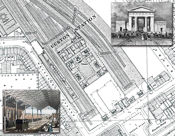
There was a notable engineering oddity about Euston from its opening on July 20 1837: because Lord Southampton, master of the Quorn Hunt, Conservative grandee, and a major landowner locally, objected to the potential noise and dirt, no locomotives were allowed between Euston and Camden Town. Instead trains were pulled from the terminus to Camden by a cable device until 1844, when engines were at last allowed.

The station grew rapidly over the following years as traffic increased. It was greatly expanded in the 1840s, with the opening in 1849 of the spectacular Great Hall, designed by Hardwick’s son Philip Charles Hardwick in classical style. It was 126 ft long, 61 ft wide and 64 ft high, with a coffered ceiling and a sweeping double flight of stairs leading to offices at its northern end.

The pioneers who established the railway network built Euston Arch, the massive Doric portico, outside the first terminus in London, Euston Station; in the 1960s their ancestors knocked it down in what many consider to be an act of cultural vandalism. Perhaps there is hope for this generation as a campaign now exists to have the Euston Arch restored.

If you have an interesting story and would like to see a historical map of your area then why not let us know by emailing us.