10% OFF – CHRISTMAS SALE

C-XMAS17

CHRISTMAS SALE – 10% OFF ALL MAPS

• Cassini Maps make Ideal Gifts for all the family.
• Order now! Last chance before for Christmas!
• A great way to compare the past with the present
• For anyone with an interest in history: friends, family or even treat yourself
• Simply use the code C-XMAS17 when prompted during checkout to receive your 10% discount. Postage and package applies as normal.

Happy Christmas from Cassini

Visit www.cassinimaps.co.uk now and see which maps we have available for your area. Buy them for yourself or make a present of the past to someone in your life.

Regards

Cassini Publishing Ltd.

November Sale – 20% OFF!

Cassini Maps Sale November 2017
Diverting, decorative and practical presents for anyone with any interest in the past.
Personalised maps centred on the location of your choice.

• Ideal gifts for Christmas
• For your friends or relatives or even for yourself!
• Maps for England, Wales, Scotland and Ireland
• Folded Maps, Deluxe Framed Maps, Classic Frame, Canvases, Downloads, Town Plan Maps, Parish Maps, Mugs…

Use coupon code C-Nov17. Simply enter the code when prompted during checkout.

Visit www.cassinimaps.co.uk

(Valid until 19th November 2017. P&P applies as normal.)

Rochdale Equitable Pioneers Society AKA the CO-OP

A-toadlane

Map: Ordnance Survey Town Plan 1:500 first published 1908

The Rochdale Society of Equitable Pioneers was a group of 28 that was formed in 1844. The society was made up from a variety of local trades with more than half involved in the production of textiles  – ten of them flannel weavers whilst others were cloggers, shoemakers, joiners or cabinet makers, but they united in common cause against the oppressive poverty facing their community in 1840s Rochdale.

As mechanisation forced more and more skilled workers into poverty, these tradesmen decided to band together to open their own store selling food items they could not otherwise afford. With lessons from prior failed attempts at co-operation in mind, they designed the now famous Rochdale Principles, and over a period of four months they struggled to pool £1 per person for a total of 28 pounds of capital. On 21 December 1844, they opened their store in 31 Toad Lane with a very meagre selection of butter, sugar, flour, oatmeal and a few candles. Within three months, they expanded their selection to include tea and tobacco, and they were soon known for providing high quality, unadulterated goods. Ten years later, the British co-operative movement had grown to nearly 1,000 co-operatives. Although other co-operatives had preceded them, the Rochdale Pioneers’ co-operative became the prototype for societies in Great Britain.

A visitors book was kept in Toad Lane from the 1860s and shows the range of their influence. By 1862 German, Spanish and Russian visitors had made their way to Rochdale to see how a successful co-operative was run. The following year Alexander Campbell, the Scottish Owenite and originator of the dividend signed the book. The first Japanese signatory was Tomizo Noguchi in 1872.

Rochdale Pioneers traded independently until 1991, with name changes inspired by mergers with neighbouring co-operatives, finally ending up today as the The Co-operative Group.

To find maps of your are visit Cassini Maps

When is a railway not a railway?

Surry_Iron_Railway

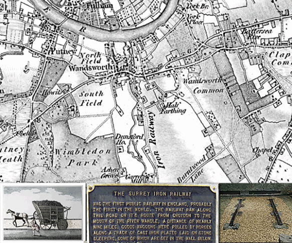
The Surrey Iron Railway, Wandsworth, London: Ordnance Survey Old Series 1805

The Surrey Iron Railway (SIR) was first public railway independent of a canal to be built by Act of Parliament (1801).

Although private railways were already in operation around Britain these were used exclusively by the owners of mines and quarries for moving their own goods. The SIR was different, it levied Tolls allowing independent goods hauliers to use their own wagons (with wheels at a suitable distance apart) pulled by horses.

Opened in 1803 it ran for approximately nine miles along the side of the River Wandle from Wandsworth Wharf, on the River Thames, towards Mitcham and Croydon

The Surrey Iron Railway is famous for being the first company in the world to include the word “railway” in it’s title.  Despite this it was not what we today would recognise as a railway.  It was actually a plateway, where vehicles with plain wheels ran along flanged rails.

The track comprised iron L-section rails 4ft 2in (1.27m) apart secured onto stone blocks. The trucks were horse-drawn, typically 8ft x 4ft x 2ft deep and weighing about 1 tonne. They could carry 3 tonnes of coal, lime or grain. One horse could pull up to ten wagons but the usual number was about four.

The original plan for a transport connection between Wandsworth, on the River Thames, and the Wandle Valley had been for a canal, but doubts about the availability of water led to the adoption of a plateway.

The railway was only briefly successful financially. It lost much traffic after the Croydon Canal opened in 1809 and continued to decline as steam railways took hold. The advent of faster and more powerful steam locomotives spelled the end for horse-drawn railways. In 1823, William James, a shareholder in the railway, tried to persuade George Stephenson to supply a locomotive. Stephenson realised that the cast-iron plateway could not support the weight of a locomotive and declined and railway was finally closed to traffic on 31st August 1846.

Find out more about your area

From a fleece to a coat in 24 Hours

NewburyCoat

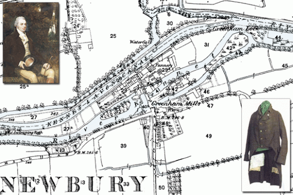
Newbury, Berkshire – Map: Ordnance Survey Old Series 1817

In June 1811, John Coxeter,  a well-known cloth manufacturer, the owner of nearby Greenham Mills, took on the challenge of the making of a legendary coat for Sir John Throckmorton.

Coxeter, is reported to have said “So great are the improvements in machinery I have lately introduced into my mill, that I believe that in twenty- four hours I could take the coat off your back, reduce it to wool, and turn it back into a coat again”.

So impressed was Sir John with Coxeter’s claim that not long after the conversation had taken place, Sir John Throckmorton laid a bet of a thousand guineas that at eight o’clock in the evening of June the 25th, 1811, he would sit down to dinner in a well-woven, properly-made coat, the wool of which would come from fleeces still on the sheeps’ backs at five o’clock that same morning. Most thought the feat impossible and it was not long before his bet was eagerly accepted.

Promptly at five o’clock operations commenced, and no time was lost in getting the sheep shorn, the wool was washed, spun, and woven. The cloth was manufactured, dyed and prepared by four o’clock in the afternoon. Just eleven hours after the arrival of the two sheep in Coxeter’s mill-yard. The cloth was now put into the hands of the tailors. Mr. James White, together with nine of his men, began the process of turning the cloth into a “well woven, properly made coat”. For the next two and a quarter hours the tailors were busy cutting out, stitching, pressing, and sewing on buttons and at twenty minutes past six Mr. Coxeter presented the coat to Sir John Throckmorton, who, before over five thousand people who had gathered to watch, put on the coat and sat down to dinner with 40 invited guests in time for dinner to be taken at eight o’clock that evening.

Throckmorton won his 1000 guineas and John Coxeter had the sheep roasted for the crowds that had gathered to see the fun, as well as donating 120 gallons of beer in one of the greatest publicity stunts of the age.

The original coat is still displayed at Coughton Court near Alcester the seat of the Throckmorton family since 1409.

Newbury, however, has its own version of the coat, produced when the feat was repeated in 1991 – knocking a further hour off the record!

Find out more about your area

Shakespear’s birthplace

shakespear2

Shakespear’s birthplace, Henley Street.  (MAP: 1886 – Town Plan, Scale: 1:500)

Shakespeare’s Birthplace is a 16th-century half-timbered house situated in Henley Street, Stratford-upon-Avon, Warwickshire, where it is believed that William Shakespeare was born in 1564 and spent his childhood years. Shakespeare is also known to have spent the first five years of married life in this house with his new wife, Anne Hathaway.

The house itself is relatively simple, but for the late 16th century it would have been considered quite a substantial dwelling. John Shakespeare, William’s father, was a glove maker and wool dealer, and the house was originally divided in two parts to allow him to carry out his business from the same premises.

The building is typical of the times and was constructed in wattle and daub around a wooden frame. Local oak from the Forest of Arden and blue-grey stone from Wilmcote were used in its construction, while the large fireplaces were made from an unusual combination of early brick and stone, and the ground-floor level has stone-flagged floors.

The plan of the building was originally a simple rectangle. From north-west to south-east, the ground-floor consisted of a parlour with fireplace, an adjoining hall with a large open hearth, a cross passage, and finally a room which probably served as John Shakespeare’s workshop. A separate single-bay house, now known as Joan Hart’s Cottage, was later built onto the north-west end of the house, and the present kitchen was added at the rear with a chamber above it.

The ownership of the premises passed to William on John Shakespeare’s death.

William already owned his own property in Stratford and had no need for the Henley Street premises as a home for himself or his family. Consequently, the main house was leased to Lewis Hiccox, who converted it into an inn known as the Maidenhead (later the Swan and Maidenhead Inn).

Under the terms of Shakespeare’s will, the ownership of the whole property (the inn and Joan Hart’s cottage) passed to his elder daughter, Susanna, upon his death.

In 1649 it passed to her only child, Elizabeth, and then in 1670 to Thomas Hart. Hart was the descendant of Shakespeare’s sister, Joan, whose family had continued as tenants of the smaller house after her death in 1646. The entire property remained in the ownership of the Harts until 1806.

Find out about the history of your area. Visit Cassini Maps

Maps, Mudge and the Census!

Mudge Map of Essex

Map: Thames Estuary (OS Old Series 1:50,000 – Published 1805)

The history of the Ordnance Survey’s mapping began in 1791 when the government, fearful of the threat of an invasion by French revolutionary forces, instructed the then Board of Ordnance to make a detailed survey of the vulnerable southern regions of England.

At the beginning of the nineteenth century some maps at the one-inch (1:63,360) scale based on Board of Ordnance surveys were already available to the public, including Kent (1801 – the ‘Mudge map’). The first published by the Ordnance Survey itself was the map of Essex which appeared in 1805. This was the start of a nationally (England & Wales) numbered map series, which later became known as theOld Series.

On the 10th March 1801, the same year as the ‘Mudge Map’ of Kent was published, the first official census was held in Britain.

Objections were raised as some felt that the census was aimed at extracting revenue. Others feared that in the era of the Napoleonic Wars the information would inevitably see its way into the hands of the enemy, allowing Bonaparte to plan an invasion of the British Isles.

By 1800 the need for a census had become greater than the resistance to it. Talk of population growth outstripping the ability of the country to feed that population was a forceful argument in favour of compiling the statistics.

Thus the Census Act of 1800 was passed on 3rd December 1800, receiving royal assent on the 31st December and  the census was carried out on Monday March 10th 1801.

Estimates of the size of the population varied from 8 million to 11 million. The actual figures proved to be: 8.3 million people in England – women outnumbering men by 300,000; the Welsh population was 542,000; and Scotland 1.6 million. Thus the total population at the beginning of the 19th century was officially recorded as 10.4 million.

Find out about the history of your area. Visit Cassini Maps
Moreton. More to Chew on!

Chew Valley

Moreton, Chew Valley, Somerset (OS County Series 1:2,500 – Published 1885-1886)

Chew Valley Lake is a large reservoir in the Chew Valley, Somerset, England, and the fifth-largest artificial lake in the United Kingdom, with an area of 1,200 acres (4.9 km²). The lake, created in the early 1950s and opened by Queen Elizabeth II in 1956, provides much of the drinking water for the city of Bristol and surrounding area.

Under the waters of Chew Lake lies the small hamlet of Moreton. It was mentioned in the Domesday Book and, at the time of its drowning, included a mediaeval chapel, a moated house and a mill. Roman buildings and flints were also found on the site.

Before the lake was created, archaeological investigations were carried out that showed evidence of occupation since Neolithic times and finds of Roman artefacts. Excavations found evidence of a thriving community in medieval times and what is reportedly the remains of the Nunnery of Santa Cruz.  Moreton was also the site of gunpowder mill in the 18th century.

Prior to the flooding of the reservoir excavations of the surrounding area were carried out. The excavations found evidence of habitation dating from the Old, Middle and New Stone Age, Bronze Age and Iron Age. Evidence included implements such as stone knives, flint blades and the head of a mace, along with buildings and graves.

What evidence is left of the area of Moreton today? The historical maps are now the only way to view the details of the landscape and understand the generations of occupation of Chew Valley.

Find out about the history of your area. Visit Cassini Maps

Charles Dickens birthplace

dickens

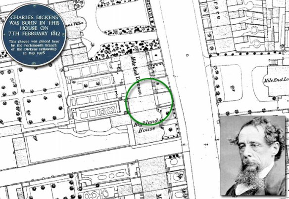
Map: County Series town Plan 1:500 – published 1874

Charles Dickens birthplace

Charles John Huffam Dickens was born at 1 Mile End Terrace (now re-named 393 Old Commercial Road), a secluded and peaceful area of victorian and regency buildings, on 7th February 1812. When Dickens was born, Britain’s Navy was still at war with Napoleonic France and Charles’s father, John Dickens worked as a clerk in the Navy Pay Office.

This was his parents first home and they were to remain in Portsmouth until the winter of 1814 when his father was recalled to London. Charles later remembered that when they left the town it was covered in snow.

Dickens completed the first of his Christmas stories, A Christmas Carol in just six weeks, with the final pages written in early December of 1843. The story met with instant success and critical acclaim and the phrase “Merry Christmas” was popularised following the appearance of the story and has remained as part of Christmas around the world ever since.

Merry Christmas from Cassini.
Discover maps of your area. Visit Cassini Maps