From a fleece to a coat in 24 Hours

NewburyCoat

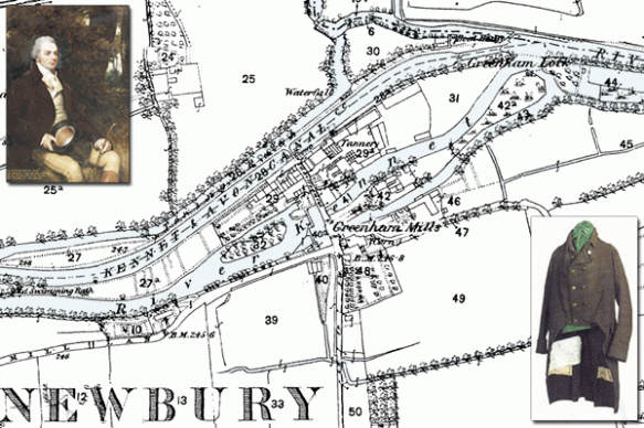
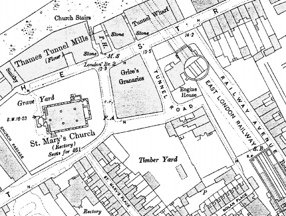
Newbury, Berkshire – Map: Ordnance Survey Old Series 1817

In June 1811, John Coxeter,  a well-known cloth manufacturer, the owner of nearby Greenham Mills, took on the challenge of the making of a legendary coat for Sir John Throckmorton.

Coxeter, is reported to have said “So great are the improvements in machinery I have lately introduced into my mill, that I believe that in twenty- four hours I could take the coat off your back, reduce it to wool, and turn it back into a coat again”.

So impressed was Sir John with Coxeter’s claim that not long after the conversation had taken place, Sir John Throckmorton laid a bet of a thousand guineas that at eight o’clock in the evening of June the 25th, 1811, he would sit down to dinner in a well-woven, properly-made coat, the wool of which would come from fleeces still on the sheeps’ backs at five o’clock that same morning. Most thought the feat impossible and it was not long before his bet was eagerly accepted.

Promptly at five o’clock operations commenced, and no time was lost in getting the sheep shorn, the wool was washed, spun, and woven. The cloth was manufactured, dyed and prepared by four o’clock in the afternoon. Just eleven hours after the arrival of the two sheep in Coxeter’s mill-yard. The cloth was now put into the hands of the tailors. Mr. James White, together with nine of his men, began the process of turning the cloth into a “well woven, properly made coat”. For the next two and a quarter hours the tailors were busy cutting out, stitching, pressing, and sewing on buttons and at twenty minutes past six Mr. Coxeter presented the coat to Sir John Throckmorton, who, before over five thousand people who had gathered to watch, put on the coat and sat down to dinner with 40 invited guests in time for dinner to be taken at eight o’clock that evening.

Throckmorton won his 1000 guineas and John Coxeter had the sheep roasted for the crowds that had gathered to see the fun, as well as donating 120 gallons of beer in one of the greatest publicity stunts of the age.

The original coat is still displayed at Coughton Court near Alcester the seat of the Throckmorton family since 1409.

Newbury, however, has its own version of the coat, produced when the feat was repeated in 1991 – knocking a further hour off the record!

Find out more about your area

Map of the month – Rugby, men and odd shaped balls.

Rugby School

Rugby School, Warwickshire (MAP: OS Town Plans 1:500 – published in 1887)

Nearly two centuries of Rugby’s history are written in the stones that stand around Rugby School, where in 1823 William Webb Ellis is said to have first picked up the ball and run, hence inventing the game of rugby football.

Although the evidence for the story is doubtful, it was immortalised at the school with a plaque unveiled in 1895.

Webb Ellis was born in Salford, Lancashire in November 1806. After the death of his father, his mother decided to move to Rugby, Warwickshire so that William and his older brother Thomas could receive an education at Rugby School with no cost as a local foundationer (i.e. a pupil living within a radius of 10 miles of the Rugby Clock Tower).

After leaving Rugby in 1826, he went to Brasenose College, Oxford. He played cricket for his college, and for Oxford University After graduation he entered the Church and became chaplain of St George’s Chapel, Albemarle Street, London and then rector of St. Clement Danes in The Strand.

He never married and died in the south of France in 1872. His grave in “le cimetière du vieux château” at Menton in Alpes Maritimes was rediscovered by Ross McWhirter in 1958 and has since been renovated by the French Rugby Federation.

The players then were more numerous: in 1839, when Queen Adelaide visited the School, it was School House versus The Rest.  The School House team numbered 75 boys and The Rest 225.

A significant event in the early development of rugby football was the production of the first written laws of the game at Rugby School in 1845, which was followed by the ‘Cambridge Rules’ drawn up in 1848 leading to the formation of the Rugby Football Union in 1871.

The code was originally known as “rugby football”; it was not until after the schism in England in 1895, which resulted in the separate code of rugby league, that the sport took on the name “rugby union” to differentiate it from the league game. Despite the sport’s full name of rugby union, it is known simply as rugby throughout most of the world.

Despite the doubtful evidence, the current Rugby World Cup trophy is named after Webb Ellis.

Find out about the history of your area. Visit Cassini Maps

Map of the month – Webb, Dover & JellyFish

Captain nWebbDover, Kent (MAP: OS Revised New 1:50,000 – published in 1898)

Captain Matthew Webb was born at Dawley in Shropshire, one of twelve children. He acquired his ability to swim in the River Severn at Coalbrookdale.

At age twelve Webb joined the merchant navy, starting with a three-year apprenticeship. Later, whilst serving as second mate on the Cunard Line ship Russia, he attempted to rescue a sailor, who had fallen from the rigging of the ship, by diving into the sea in the mid-Atlantic. Webb swam for more than half-an-hour, but the man was never found. Webb’s daring won him an award of £100 and the first Stanhope Medal, and made him a hero of the British press.

In 1873, Webb was serving as captain of the steamship Emerald when he read an account of the failed attempt by J. B. Johnson to swim the English Channel. He became inspired to try himself.

On 12 August 1875, he made his first cross-Channel swimming attempt, but strong winds and poor sea conditions forced him to abandon the swim. Just 10 days after this first abortive attempt, on August 24 1875 Webb dived from Dover ’s Admiralty Pier and headed towards France. Porpoise-grease helped insulate him against the cold, but couldn’t prevent the pain of numerous jelly-fish stings. Tantalisingly close to the French shore strong currents prevented him from completing the last few miles for several hours; but eventually the currents slowed and his steady breast-stroke won out. Webb walked ashore some 21 hours and 45 minutes after he left England. His zig-zag course across the Channel had totalled over 39 miles (64 km). He was an instant national hero.

After his record swim, Captain Webb basked in national and international adulation, and followed a career as a professional swimmer. He licensed his name for merchandising such as commemorative pottery and wrote a book called The Art of Swimming. A brand of matches was named after him. He also participated in exhibition swimming matches and stunts such as floating in a tank of water for 128 hours… don’t tell David Blaine.

Find out about the history of your area. Visit Cassini Maps


Map of the month – Botchergate, Trollope and the Bellman

First Postbox - CarlisleBotchergate, Carlisle (MAP: OS Town Plans 1:500 – published in 1865)

vertical-pillarbox

Thirteen years after Sir Rowland Hill, Secretary of the Post Office, introduced the Penny Post that the first mainland Pillar Box was erected in Botchergate, Carlisle in 1853.

The advent of the British wayside letter box can be traced to Sir Rowland Hill and his Surveyor for the Western District, and noted novelist, Anthony Trollope (known for The Warden, Barchester Towers and the Palliser novels).

Before 1853 it was customary to take outgoing mail to the nearest letter receiving house or post office, where the Royal Mail coach would stop to pick up and set down mail and passengers. People would take their letters in person, or in some areas they could await the appearance of the Bellman. The Bellman wore a uniform and walked the streets collecting letters from the public while ringing a bell to attract attention.

In 1852 Anthony Trollope was sent by Rowland Hill to the Channel Islands to ascertain what could be done about the problem of collecting the mail on the islands. To post a letter in Jersey or Guernsey, the post had to be taken down to the quayside and handed to the Master of the Royal Mail steamer in person. This was a somewhat inconvenient practice, subject as it was to the uncertainties of weather and tides.

Trollope’s recommendation back to Hill was to employ a device he had probably seen in Paris: a “letter-receiving pillar”. The first pillar boxes was brought into public use on Jersey in late November 1852 and they were an instant success.

By the next year the idea had spread to mainland Britain, with England’s first pillar box erected at the corner of Botchergate and South Street in Carlisle. In basic form all boxes were vertical cast iron ‘pillars’ with a small vertical slit to receive letters, but by 1857, after experimenting with various designs, horizontal, rather than vertical, slots were taken as a standard. The Committee responsible for the standardisation designed a very ornate box festooned with Grecian style-decoration but, in a major oversight, devoid of any posting aperture, which meant the slots were chiselled out of the cast iron by local craftsmen, usually destroying the look of the box.

Prior to 1859 colours varied until a bronze green colour was chosen as the new standard, which was to last until 1874. Initially it was thought that the green colour would be unobtrusive. Too unobtrusive, as it turned out — people kept either walking into them or past them. Red became the standard colour in 1874, although ten more years elapsed before every box in the UK had been repainted.

Find out about the history of your area. Visit Cassini Maps


Cassini Maps Sale – 25% OFF!

Cassini Quad Map

Last few days of this Special Offer! – 25% Off all maps (ends 30th Sept 2015)
Use the code C-SUN15 to claim your Discount.

Simply enter the code when prompted during checkout. P&P applies as normal.
Offer applies to all maps available on www.cassinimaps.co.uk
Including our Quad maps (4 maps of the same location but from diferent time periods) as shown above.

New! – Cassini brings you Ordnance Survey’s most detailed historical mapping.
Cassini’s Town Plan mapping is the most detailed historical Ordnance Survey mapping available. Easy to find and download.
Town Plan Map

Maps published from the mid 1800’s to the 1920’s
• Instant downloads only £9.99 (RRP:£14.99)
• Ideal for Family History research
• Choose maps from 468 available Towns
• Amazing detail – 1:500, 1:528 and 1:1056 scales (dependent on location)

These maps were published for larger towns and cities at scales of 1:500, (c.10′ to 1 mile), 1:528 (exactly 10′ to 1 mile) and 1:1056 (5′ to 1 mile) from the mid 1800’s onwards. An immense amount of detail is shown, down to every lamp-post and every pillar-box, even paths, trees and sheds in peoples gardens. For those who are particularly interested in local history and genealogy, the town plans are essential research tool.

Find maps of your area on the Cassini Maps website Town Plan Maps

A Race Track, an Airfield and Maggots

Silverstone (MAP: OS Old Series 1:50,000 – published in 1835)
Silverstone
Silverstone is a village and civil parish in Northamptonshire. The village is listed in the Domesday Book.

Silverstone is also the current home of the British Grand Prix, which it first hosted in 1948. The circuit itself straddles the Northamptonshire and Buckinghamshire border, with the current main circuit entry on the Buckinghamshire side and built on the remains of a WWII RAF base.

Even being at the forefront of technical innovation Silverstone has its roots firmly in the landscape’s past. All the corners of the racing circuit have names, many relating to the local area, as shown on the map.

• The first corner on the circuit is Abbey. Named after Luffield Abbey, which occupied the centre of the site from the twelfth century until its Dissolution in 1551 when the land was passed to Sir Francis Throckmorton.
• The second, Farm Curve, simply takes it’s name from a nearby farm.
• The third and fourth corners have literal names in Village, named after Silverstone Village and The Loop, the only corner to be named after it’s shape.
• Then there is Aintree, named after the Aintree course, where the Grand Prix alternated with Silverstone in the late 1950’s to early 1960’s.
• Followed by the Wellington Straight, only named in 2010, which takes it’s name from the Wellington Bombers which flew from RAF Silverstone during WWII.
• Next comes Brooklands, named in honour of the Brooklands Motor Circuit, known as the home of British motor racing.
• Luffield, like the first corner is named after the medieval Abbey.
• Woodecote, like Brooklands, was named in honour of an existing circuit, namely the RAC owned Woodcote Park in Surrey.
• Copse corner is named after the nearby Chapel Copse and Cheese Copse that border the track.
• The oddly named Maggotts actually takes its name from the adjacent Maggots Moor (written with only the one ‘t’ on the map).
• Becketts and Chapel Curve both take their names from the medieval chapel of St Thomas à Beckett which stood near the track features.
• Like the Wellington Straight, Hangar Straight takes it’s name from the time of the RAF base. Two of the largest hangars stood in this area.
• The next corner Stowe takes it’s name from the local area of Stowe, to the south of the track, famous for Stowe School.
• Vale. Although the track is predominantly flat, this is the only undulating area on the track and the probable source of the name. Another theory is that is named after the district of Aylesbury Vale, in which it sits.
• The final corner Club is, like Woodecote, named after the famous RAC club in Pall Mall London.

This weekend sees Silverstone hosing the British Grand Prix with nearly 300,000 people expected to attend. A far cry from the quiet landscape shown on the above 1835 map.

Find out about the history of your area. Visit Cassini Maps


Map of the month – Tunnels and a World Changer.

Welbeck Abbey  (MAP: OS County Series 1:2500 – published in 1886)
Welbeck Abbey

Welbeck Abbey in North Nottinghamshire was the site of a monastery which, after the Dissolution of the Monasteries, became the country house residence of the Dukes of Portland.

William Cavendish-Scott-Bentinck (1800-79), the 5th Duke of Portland, built a 10km-long network of underground corridors on his Welbeck Abbey estate in part of Sherwood Forest.

Cavendish-Scott-Bentinck instructed his builders to construct pathways under the 69sq km of landscaped grounds. Tunnel No. 1 was about 500m long, wide enough for two carriages and had gas lamps installed overhead and led to a 2km pathway connecting the lodge and the south lodge, where the duke’s carriage was kept. The 910m-long Plant Corridor ran between the main house and riding house and was wide enough for several people to walk side by side. Running parallel to the Plant Corridor was a longer, narrower, rougher-hewn tunnel, which the duke had built for the servants, to ensure they never met.

There are many smaller tunnels including a grotto corridor and corridors with narrow-gauge rails on which warm food could be brought on trolleys to the main house. The Horse Corridor leads to an underground ballroom, the largest private room in England at the time – 50m long and 20m high. All these projects were funded by the duke’s properties in London around Portland Square and other properties in the West End.

Many rumours surround the eccentric 5th Duke. He is said to have spent most of his life in a small five-room suite within Welbeck and that he required that a fresh roasted chicken was available at any time, day or night. On the few occasions he left his house to walk in the extensive park, it was only at night and accompanied by a servant, who carried a lantern 30m in front of him and he was observed to only leave the house concealed under an umbrella, two large overcoats, a two foot high top hat, and a double ruff – even in fine weather.

In 1913, Archduke Franz Ferdinand accepted an invitation from the 6th Duke of Portland to stay at Welbeck Abbey and arrived with his wife, Sophie, by train at Worksop on the 22nd November. This was almost a year before his assassination, which triggered off the First World War.

The Archduke narrowly avoided being killed in a hunting accident during his stay. The Duke of Portland was out shooting pheasants with Franz Ferdinand when: “One of the loaders fell down. This caused both barrels of the gun he was carrying to be discharged, the shot passing within a few feet of the archduke and myself. I have often wondered whether the Great War might not have been averted, or at least postponed, had the archduke met his death then and not at Sarajevo the following year.”

Find out about the history of your area. Visit Cassini Maps


Water Babies and an exclamation!

Westward Ho!, Devon (MAP: OS Town Plans 1:10,000 – published in 1903)
Westward Ho!
Westward Ho! is a seaside village near Bideford in Devon, England and faces westward into Bideford Bay.

The village name comes from the title of Charles Kingsley’s novel Westward Ho! (1855), which was set in nearby Bideford. The book was a bestseller, and entrepreneurs saw the opportunity to develop tourism in the area. The first hotel built was named the Westward Ho! Hotel, and the adjacent villas were also named after the book. As further development took place, the expanding area incorporated the name of Westward Ho!

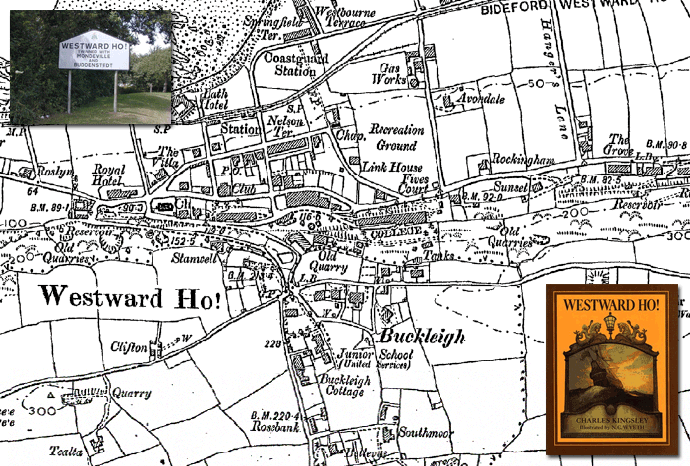
During WWII Bailey Bridges were tested at Westward Ho! as part of the Mulberry Harbour project, as well as the The Great Panjandrum. The Panjandrum is probably best know for being depicted in the Dad’s Army episode, “Round and Round Went the Great Big Wheel”, about a large, rocket-propelled, explosive-laden wheel. Unfortunately the real wheel had as many problems as the tv version and the idea never saw service.

Westward Ho! is also home to the Royal North Devon Golf Club, the oldest golf course in England and Wales.

The exclamation mark is obviously an intentional part of the village’s name. It is the only such place name in the British Isles, but although it may be unique in the UK Westward Ho! is out-exclaimed by Saint-Louis-du-Ha! Ha!, Quebec, which has the distinction of having two exclamation marks in its name.

Find out about the history of your area. Visit Cassini Maps

New Town Plans – 50% Off.

Ordnance Survey’s most detailed historical mapping

Town Plans Special Offer

Published from the mid 1800’s to the 1920’s

• Instant downloads only £7.49 (RRP:£14.99)
• Ideal for Family History research
Choose from 468 available Towns
• Amazing detail – 1:500, 1:528 and 1:1056 scales

These maps were published for larger towns and cities at scales of 1:500, (c.10′ to 1 mile), 1:528 (exactly 10′ to 1 mile) and 1:1056 (5′ to 1 mile) from the mid 1800’s onwards. An immense amount of detail is shown, down to every lamp-post and every pillar-box, even paths, trees and sheds in peoples gardens.

Cassini’s Town Plans are the most detailed historical Ordnance Survey maps available and are easy to find and download. For those who are particularly interested in local history and genealogy, the town plans are essential research tool – now half price.

See Town Plans for your area, or find other scales and map products.

Ballot Box, Balls and a Roman

Ballot Street, Smethwick (MAP: OS Town Plans 1:500 – published in 1887)
Ballot - Town Plan Maps

The map above is an example of one of Cassini’s newly available Town Plans. A great number of English towns, those with a population of over 4,000, were surveyed on the large scale of 1:500. Other early plans were published at scales of 1:528 and 1:1056, but from 1855 onwards the scale of 1:500 was settled on and most were surveyed only once. The maps, published between 1855 and 1920’s, show an immense amount of detail, down to every lamp-post and every pillar-box, even paths, trees and sheds in peoples gardens.

As we have chosen Ballot Street, here’s a bit of history you may, or may not, know. A ballot is a device used to cast votes in an election. It was originally a small ball used to record decisions made by voters. The word ballot comes from Italian ballotta, meaning a “small ball used in voting”. The first use of paper ballots to conduct an election appears to have been in Rome in 139 BC.

The coin shown above is Roman from around 63 B.C. Issued by Cassius Longinus, who became a proconsul in 48 B.C. and a Tribune of the Plebs in 44 B.C. The reverse of the coin shows a voter about to deposit a voting tablet marked V (meaning yes – ‘as you ask’) into a voting urn.

The first British secret ballot using ballot papers and a ballot box was held in Pontefract on 15 August 1872, under the terms of the recently enacted Ballot Act 1872. In a ministerial by-election following his appointment as Chancellor of the Duchy of Lancaster, Hugh Childers was re-elected as MP for Pontefract. The original ballot box, sealed in wax with a liquorice stamp, can still be seen in Pontefract Museum.

Find out about the history of your area. Visit Cassini Maps