Map of the month – The lost village of Imber

Lost Village of Imber

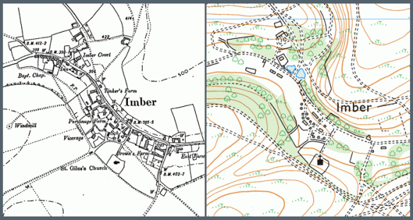
The lost village of Imber, Wiltshire (County series 1:10,000)

Described by Ella Noyes in the 1890’s, Imber was “one straggling street of old cottages and farmsteads winding along the hollow under the sheltering elms.” The village of Imber had been a remote village nestled in a small valley on Salisbury Plain in Wiltshire. It had for centuries made the most of its secluded existence by surviving largely unscathed by both civil unrest and pestilence that had from time to time existed elsewhere in England.

It was later in the 1890’s that its fortunes started to change with the arrival of the Army on Salisbury Plain. The War Office concluded its search for a large training environment with the purchase of over 40,000 acres of land on the east of the plain.

With the advent of WW1, training increased significantly around Imber with the villagers suffering virtual imprisonment as the surrounding countryside was shelled.

The village struggled to maintain its self-sufficiency on the cratered landscape it had sought to farm in the post war years and its decline continued until 1943, when, with the village now in the centre of the military’s western ranges, the inhabitants were given 46 days to leave.

There is little of the original village remaining today and nearly half of the standing structures were built by the army.

If you have an interesting story and would like to see a historical map of your area then why not let us know by emailing us.

Coastal erosion and the vanishing towns

Ordnance Survey Old Series – 1837 and Ordnance Survey – 2013

Coastal Erosion on the East Coast

Covehithe

is a hamlet and civil parish in the Waveney district of the English county of Suffolk.
It lies on the North Sea coast around 4 miles north of Southwold and 7 miles south of Lowestoft.

In the Domesday survey of 1086 the village is named as Nordhalla or Nordhals and is recorded as being a medium sized settlement with 13 households of freemen or smallholders.

In the Middle Ages Covehithe prospered as a small town and during the reign of Edward I was granted the right to hold a fair on the feast day of St Andrew. By the 17th Century however it had fallen victim, like nearby Dunwich, to coastal erosion and now modern Covehithe has a population of around 20.

Cliff edgeErosion caused the coastline at Covehithe to retreat more than 500 metres between the 1830s and 2001, according to contemporary Ordnance Survey maps. This can be seen most obviously on the sand cliffs above the beach where the road running from the church simply falls away down onto the beach.

The coastal cliffs at Covehithe are formed of glacial sands and other deposits, consequently they are loose and unconsolidated and erode at up to 4.5 metres a year. The main part of the settlement at Covehithe is around 250 metres from the current shoreline, but some say it’s possible that Covehithe could be lost to erosion by as early as 2040.

The Monty Python sketch ‘The First Man To Jump The Channel’ was partly filmed at Covehithe beach, although, of course, the Channel was narrower then…

If you have an interesting story and would like to see a historical map of your area then why not let us know by emailing us.

Find out more about your area of the UK