20% OFF all maps – One day only!
Use coupon code C-14JUNE. simply enter the code when prompted during checkout.
Visit www.cassinimaps.co.uk
(Valid until 14th June 2017. P&P applies as normal.)

20% OFF all maps – One day only!
Use coupon code C-14JUNE. simply enter the code when prompted during checkout.
Visit www.cassinimaps.co.uk
(Valid until 14th June 2017. P&P applies as normal.)
Map: Ordnance Survey County Series 1:2500 – 1886
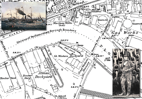
SS Great Western – the largest vessel in the world.
In 1838 after sailing to London, where she was fitted with two side-lever steam engines. the Great Western set sail for Avonmouth to start her maiden voyage to New York. The ship hadn’t gone far when a fire broke out in the engine room. During the confusion Brunel fell 20 feet, and was injured. The fire was extinguished, and the damages to the ship were minimal, but Brunel had to be put ashore at Canvey Island. As a result of the accident, more than 50 passengers cancelled their bookings for the Bristol-New York voyage and when the Great Western finally departed Avonmouth, only 7 passengers were aboard.
The Great western’s first voyage in April 1838 was set to be a race with the British and American Steam Navigation Company’s rival ship the SS Sirius but the fire delayed the Great western’s start. Even with a four-day head start, Sirius only narrowly beat Great Western, arriving in New York on 22 April. When coal ran low, the crew of the Sirius burned 5 drums of resin. The Great Western arrived the following day, with 200 tons of coal still on board. Sirius is often credited as the first winner of the Blue Riband (even though the term Blue Riband was not coined until years later) at 8.03 knots. However, Sirius only held the record for a day because Great Western’s voyage was faster at 8.66 knots.
Still capable of making record Blue Riband voyages as late as 1843. Great Western worked to New York for 8 years until her owners went out of business. She was sold to the Royal Mail Steam Packet Company and was scrapped in 1856 after serving as a troop ship during the Crimean War.
If you have an interesting story and would like to see a historical map of your area then why not let us know by emailing us.
Map: Ordnance Survey County Series 1:2,500 – 1877
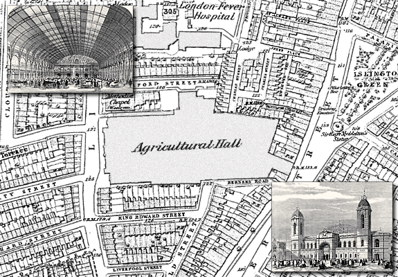
The Royal Agricultural Hall, Islington (now the Business Design Centre).This Grade II listed building was opened in 1862 and was one of the world’s largest exhibition halls of its time. It was built to provide a home to the Smithfield’s Club annual exhibitions of agricultural produce and livestock (later known as the Royal Smithfield Show).However, it has been put to many uses over time and has hosted Crufts and the Royal Tournament as well as acting a temporary Parcels Sorting Depot during WW2.
The hall fell into disrepair after the war and was not used again until 1986 when it was converted to house the Business Design Centre.
If you have an interesting story and would like to see a historical map of your area then why not let us know by emailing us.
![]() This summer sees the Business Design Centre host the 3-day
This summer sees the Business Design Centre host the 3-day
“It’s all about Art” event and workshops run by the SAA, society for all artists.
The show runs from 25th to 27th July and is an ideal opportunity to give painting a try. Whether just starting out or been painting for years, It’s all about Art will inform, encourage and inspire you to get painting and enjoy this rewarding and relaxing past time. Plus, there’s lots to see and learn whatever your ability, and you’ll have a fantastic day out with friends too.
 There’s something for everyone at this three day event and it is a great chance for you to come along and meet with celebrity TV artists, take part in hands-on workshops (with all materials included), watch demonstrations, learn handy hints and top techniques, get your hands on all the latest products and be inspired to try something new.
Tickets are just £12 each and Cassini Map customers can receive a special discounted ticket price of ‘Buy one ticket and get the second for half price’.
Just click here and enter the code CASSINI or call 0800 980 1123 and quote CASSINI when ordering. Why not order some tickets today as they make a great Father’s day gift too.

Map: Ordnance Survey 1:2500 County Series from 1875 – Bray, Berkshire.
Down Place country house (1750) and Oakley Court, a castellated and turreted Gothic mansion (1857) were built on the banks of the River Thames between the towns of Bray and Windsor and went on to find fame and fortune as Bray Studios.
In 1951 Hammer Film Productions settled on the derelict Down Place as a way of avoiding the need to build sets and the large grounds were ideal for location work for their budget horror films. The following year Hammer decided to build a full studio in the grounds of Down Place, and name it Bray Studios, after the local town. Oakley Court was acquired in the 1960’s and became an ideal setting for many Bray productions.
Films included the 1950’s films The Quatermass Xperiment, The Curse of Frankenstein, Dracula and the Mummy. The 1960’s saw The Brides of Dracula, The Two Faces of Dr. Jekyll, The Curse of the Werewolf, and many, many more. The last Hammer production made at Bray was The Mummy’s Shroud, which wrapped on 21 October 1966.
Bray went on to produce many other films including the St Trinians series and The Rocky Horror Picture Show, as well as special effects and model work for TV and film. including Doctor Who, Space 1999, Alien, Captain Corelli’s Mandolin and Terry Gilliam’s 2009 film The Imaginarium of Doctor Parnassus.
Due to the size of its sound stages and it’s relative remoteness, Bray Studios also became a popular rehearsal studio where many artists fine-tuned their performances before going on tour. From Led Zeppelin in the 1970’s to The Kings of Leon in 2008, by way of Queen’s Freddy Mercury tribute concert, Cream, George Harrison, Radiohead and Amy Winehouse, the studios became home to many of the worlds top bands.
On the opposite side of the Thames lies Eton Dorney, the scene of rowing triumphs in the 2012 Olympic rowing events, where Team GB won four gold medals, two silver and three bronze.
The town of Bray is also famed for its culinary delights, boasting two of the four restaurants in the United Kingdom to have three Michelin stars, The Waterside Inn founded by the Roux brothers, and Heston Blumenthal’s Fat Duck restaurant.
If you have an interesting story and would like to see a historical map of your area then why not let us know by emailing us.

Map: The Roberts Grocery Shop, Grantham – Ordnance Survey 1:2500 County Series from 1888
Whether you loved or hated her, Margaret Thatcher was adored by her husband, Sir Denis Thatcher. Major Sir Denis Thatcher, 1st Baronet, MBE was born in Lewisham in 1915, He served in the WWII gaining the temporary rank of Major and was appointed MBE in 1945 for his services during Operation Goldflake (the movement of Canadian combatant units from Italy to North-West Europe). He was awarded the hereditary title, 1st Baronet, in 1991. He was a successful businessman and millionaire in his own right.
Today, he’s also remembered as being the husband of the late Baroness Thatcher, Britain’s ex Prime-Minister.
However, she wasn’t the first Margaret to marry Denis.Margaret Thatcher, the first, was in fact Margaret Kempson who married Denis in 1942. Denis was already serving abroad and so they saw little of each other during the war. After being demobilised in 1946, the first Maggie Thatcher announced she had met someone else and filed for divorce. Denis met the second more famous Maggie Thatcher (née Roberts) in 1949 and married her in 1951. Thatcherism rather than Robertsism is recorded in the annals of history .
If you have an interesting story and would like to see a historical map of your area then why not let us know by emailing us.
Come and meet Cassini on stand:522 of this years Who Do You Think You Are – Live.

“Finding your ancestors just got easier at the world’s leading family history event! Whether you’re new to tracing your family tree or a seasoned researcher, it’s packed with genealogy experts, informative workshops, over 160 specialist exhibitors and celebrities from the television series to help you with your own family history search.”
Cassini will be attending the event so drop in and say hello – and while you’re there have a look at the maps on offer. It’s a great way to see before you buy.
For more information about Who Do You Think You Are – Live visit the website
Twickenham Stadium
If you have an interesting story and would like to see a historical map of your area then why not let us know by leaving a reply?
Ordnance Survey County Series 1:2500 scale with present-day aerial photo overlay.
This weekend, Twickenham Stadium will host the England – France Rugby Union match – sometimes known as le Crunch. This is the 84th time the 2 sides have met in the Six Nations (previously Five Nations) Championship.
Although the teams had met from 1906, the first match between the 2 nations in this Championship was played at the Parc des Princes in Paris in 1910 (France winning 11-3).
The following year, they met at Twickenham with an English victory of 37-0.
The map here shows the land prior to being bought by the RFU in 1907 with an overlay of the Stadium today. England had previously hosted their international matches at Crystal Palace, Richmond Athletic Ground or at Welford Road in Leicester.
The RFU, advised by their committee member William Williams and their treasurer William Cail that a new RFU home was needed, decided to buy the land on the east bank of the River Crane near the village of Whitton and to the north of the town of Twickenham.
Part of the land purchased was a market garden growing cabbages – the Stadium today is still affectionately known as the Cabbage Patch.
The first game played at the ground was in 1909 between local teams, Harlequins and Richmond. The first international match was played the following year between England and Wales.
The Stadium’s original capacity was 20,000 spectators, today, after much redevelopment, it can hold 82,000 making it the second largest stadium in the UK after Wembley and the fifth largest in Europe.
Apart from a brief spell as grazing land during WW1, it has remained the world’s largest stadium dedicated solely to rugby – although it has hosted numerous rock concerts and even a BBC Top Gear Car Rugby match…
Greenwich meridian chosen as the official prime meridian.
From the 17th century onwards Greenwich, home to the national observatory, had been the centre for the study of time as well as the skies, the link being the need for accurate timekeeping for navigation. Accordingly, a meridian at the Greenwich Observatory(originally the site of Greenwich Castle, constructed by the Duke of Gloucester, in 1433) was set, by the British, as the zero point of reference for determining time and longitude.
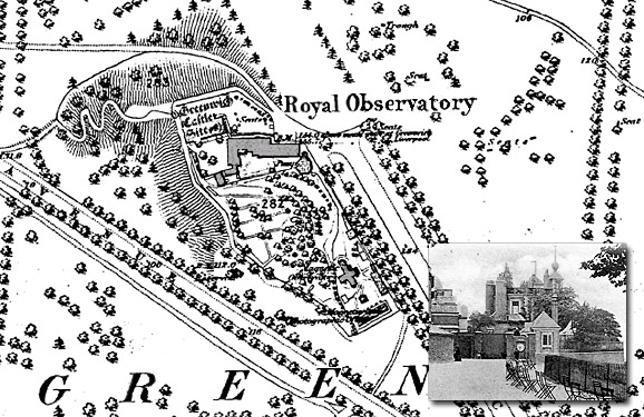
Greenwich Mean Time was first adopted across the island of Great Britain by the Railway Clearing House in 1847 to standardise train timetables, and by almost all railway companies by the following year. By the end of 1880 GMT had been legally adopted throughout the island of Great Britain.
Whatever your interest in the past our historical maps are invaluable works of reference. Ideal for reasearch, or print and frame for a personalised decorative map centred on the location of your choice.
“…and the crowd goes wild at the Bone Works end!“

Map of the week – Stratford 1894 OS County Series 1:10,000
For those lucky enough to have a ticket to the Olympic stadium you may find yourselves sitting in what could be called the ‘Bone Works’ end.
It is common practice for the stands of modern stadia to be named after features and locations in the local environment. By looking at this County Series map from 1894, two years before the first modern games were held in Athens, you can see how the history of the landscape could influence the naming of the present day stadium.
So, if you hear people mentioning the Knobshill stand overlooking the one hundred metres track, the Distillery stand opposite or even the Tallow Works end, you’ll know that, for some, Stratford’s past lives on. Find maps of your area.
Britain is awash with extraordinary place names, as anyone from Lumps of Garryhorn, Nempnett Thurbwell or Nether Wallop (to choose but three) will be well aware.
 Cassini has decided that some of these are so spectacularly rude that they deserve wider publicity; and, to prove that they’ve existed for years and that they are real names, we’ve located each of them on a historical map and turned them into a unique set of greeting cards.
The cards were first seen at this year’s Spring Fair at the NEC in early February 2011. The interest and popularity of the cards at the show persuaded us to bring forward their publication.
Old Hag, Hairy Ness, Ugley and Boobys Bay are here; so are Brownwilly, Pratt’s Bottom,Sandy Balls, and many others too rude to publish here.
Each has a dated historical map centred on the unfortunate place name and a grid reference should you want to visit it for yourself. The inside is blank for further insults, or explanations. There are 24 cards in this first series, with more series planned for later in 2011. They’ll bring a laugh out loud, a smirk or a grimace – either way, they’ll entertain and appeal to everyone. So now, when you send a greeting card, you can say what you really mean…
