Water Babies and an exclamation!

Westward Ho!, Devon (MAP: OS Town Plans 1:10,000 – published in 1903)
Westward Ho!
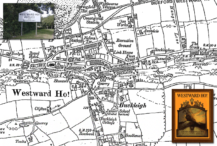
Westward Ho! is a seaside village near Bideford in Devon, England and faces westward into Bideford Bay.

The village name comes from the title of Charles Kingsley’s novel Westward Ho! (1855), which was set in nearby Bideford. The book was a bestseller, and entrepreneurs saw the opportunity to develop tourism in the area. The first hotel built was named the Westward Ho! Hotel, and the adjacent villas were also named after the book. As further development took place, the expanding area incorporated the name of Westward Ho!

During WWII Bailey Bridges were tested at Westward Ho! as part of the Mulberry Harbour project, as well as the The Great Panjandrum. The Panjandrum is probably best know for being depicted in the Dad’s Army episode, “Round and Round Went the Great Big Wheel”, about a large, rocket-propelled, explosive-laden wheel. Unfortunately the real wheel had as many problems as the tv version and the idea never saw service.

Westward Ho! is also home to the Royal North Devon Golf Club, the oldest golf course in England and Wales.

The exclamation mark is obviously an intentional part of the village’s name. It is the only such place name in the British Isles, but although it may be unique in the UK Westward Ho! is out-exclaimed by Saint-Louis-du-Ha! Ha!, Quebec, which has the distinction of having two exclamation marks in its name.

Find out about the history of your area. Visit Cassini Maps

Mapmaker Plus – Price drop!

Create your own bespoke maps with Mapmaker Plus.

Mapmaker PlusNow available from £14.99

Large format maps supplied folded or rolled. A total combination of 13 map scales and series. Maps available from 1805 to the present day. Choose from seven OS Historical Map Series.

Now includes six present day Ordnance survey mapping series.

• Centred on a location of your choice            • Never be on the edge of a map again
• Ideal for creating your own walking maps   • Explore the past with a historical map

Check out Cassini Mapmaker Plus custom made maps: Mapmaker Plus

Old Parish Maps – Reduced to £5.99

Cassini Old Parish Map

One week Special Offer RRP £12.99 – Now only £5.99
Offer ends 16th Feb 2015

Cassini Maps has created 14,659 individual historical Parishes Maps, which form an essential resource for local history researchers, genealogists and historians. As parish boundaries have changed over time, its essential to know where your ancestors lived and to understand the landscape that shaped their lives.

• Parish Maps provide a direct link to Census and Parish Records.
• Download the PDF to view on screen and print at home.
• Parish boundaries as they were in 1911.
• Detailed Ordnance Survey mapping published between 1880 – 1910.
• Downloadable PDFs of English and Welsh Parishes.
• Scale: Street-level mapping – 1:10,000 (originally 1:10,560).

(Sample)  (Keys & Legends)

14,659 individual historical Parishes Maps are now available to download and to print at home. These maps provide a vital link to Parish Records and show in great detail the historical Parishes in which your ancestors lived and worked. Each maps is taken from the Ordnance Survey County Series 1:10,560 maps from the cusp of 19th and 20th centuries and show the Historical Parish Boundary as recorded at the time of the 1911 census.

To buy your Old Parish Maps please visit Cassini Maps

Historical Map Downloads – Half price!

Cassini Downloadable maps
Warnborough - 1871. 1:2,500

From only £3.99 – One week only. Offer finishes on the 16th February 2015
Coverage – England, Scotland, Wales.
Ideal for research, or print and frame for a personalised decorative map centred on the location of your choice. A4 maps £3.99, A3 maps £4.99

Cassini’s downloadable maps from 1805 to the present day.

• Instant map downloads of any area.  • Including personal inscription.
• Available for all historical OS series. • Choose from eight historical map series
• Highly customisable.                          • Coverage of England, Scotland* and Wales.

Cassini is delighted to offer you our stunning range of historical Ordnance Survey maps. Whatever your interest in the past our historical maps are invaluable works of reference. Ideal for reasearch, or print and frame for a personalised decorative map centred on the location of your choice.

Simply search for the area you are interested in, buy and download the PDF. No waiting for the map to arrive in the post.

Maps available for site-centred downloads
1855-1896 County Series 1:2,500
1880-1910 County Series 1:10,000
1805-1874 Old Series 1:30,000 – 1:50,000
1871 Registration District 1:30,000 – 1:50,000
1896-1904 Revised New 1:30,000 – 1:50,000
1919-1926 Popular Edition 1:30,000 – 1:50,000
1945-1948 New Popular 1:30,000 – 1:50,000
Present Day Ordnance Survey 1:30,000 – 1:50,000

*Scottish maps are only available for Old Series 1805-1874, Revised New Series 1896-1904 and Presentr Day OS mapping.

Visit Cassini Maps to find maps of your area.

14,659 Parish Maps from England and Wales!

OPM2
Cassini – Old Parish Maps

RRP £12.99 Introductory offer – Now only £4.99
Offer ends 31/10/2014

(Sample)  (Keys & Legends)

Cassini Maps has created these Old Parish Maps an essential resource for family history researchers, genealogists and historians. As parish boundaries have changed over time, its essential to know where your ancestors lived and to understand the landscape that shaped their lives.

• Parish Maps provide a direct link to Census and Parish Records.
• Download the PDF to view on screen and print at home.
• Parish boundaries as they were in 1911.
• Detailed Ordnance Survey mapping published between 1880 – 1910.
• Downloadable PDFs of English and Welsh Parishes.
• Scale: Street-level mapping – 1:10,000 (originally 1:10,560).

Visit Cassini’s Old Parish Maps page

14,659 individual historical Parishes Maps are now available to download and to print at home. These maps provide a vital link to Parish Records and show in great detail the historical Parishes in which your ancestors lived and worked. Each maps is taken from the Ordnance Survey County Series 1:10,560 maps from the cusp of 19th and 20th centuries and show the Historical Parish Boundary as recorded at the time of the 1911 census.

About the Maps
The origins of the six-inch to the mile maps (1:10,560) date back to 1824 when this scale was adopted for a survey of Ireland. By 1840 it had been decided to extend the project to Great Britain. To conduct a survey at such a scale, every corner of the country, including private property, would need to be visited. The following year, the Survey Act was passed which gave surveyors the right to enter any land for the purposes of carrying out their duties. It also specified the types of boundaries that the new maps were to display (down to parish level).

Cassini has reproduced County Series Parish Maps for the whole of England and Wales. This involved combining more than one original sheet to give an appropriate area of coverage. In the process, the maps have been digitally enhanced and enlarged slightly to 1:10,000 to bring them into line with more recent maps at this metric scale.

Cassini Maps

Map of the month – The lost village of Imber

Lost Village of Imber

The lost village of Imber, Wiltshire (County series 1:10,000)

Described by Ella Noyes in the 1890’s, Imber was “one straggling street of old cottages and farmsteads winding along the hollow under the sheltering elms.” The village of Imber had been a remote village nestled in a small valley on Salisbury Plain in Wiltshire. It had for centuries made the most of its secluded existence by surviving largely unscathed by both civil unrest and pestilence that had from time to time existed elsewhere in England.

It was later in the 1890’s that its fortunes started to change with the arrival of the Army on Salisbury Plain. The War Office concluded its search for a large training environment with the purchase of over 40,000 acres of land on the east of the plain.

With the advent of WW1, training increased significantly around Imber with the villagers suffering virtual imprisonment as the surrounding countryside was shelled.

The village struggled to maintain its self-sufficiency on the cratered landscape it had sought to farm in the post war years and its decline continued until 1943, when, with the village now in the centre of the military’s western ranges, the inhabitants were given 46 days to leave.

There is little of the original village remaining today and nearly half of the standing structures were built by the army.

If you have an interesting story and would like to see a historical map of your area then why not let us know by emailing us.

Map of the week – Aintree and the Grand National

Aintree Race Course  and the Grand National
Aintree Race Course
Map: Ordnance Survey 1:10,000 County Series from 1906

The Grand National is held annually at Aintree Racecourse in Liverpool, England. First run in 1839, it is a handicap steeplechase over 4 miles 3½ furlongs (7,200m) with horses jumping 30 fences over two circuits of the racecourse.

The most valuable jump race in Europe, with a prize fund of £975,000, It is popular amongst many people who do not normally watch or bet on horse racing  first run in 1839 and has a special place in the hearts and minds of the UK public with bets expected to exceed £350 million.

The Grand National is not without it’s detractors. As one of the toughest, if not the toughest race in the world it has witnessed a documented 70 horses die since the first race in 1839, along with one jockey, Joseph Wynne, who was racing in his first Grand National in 1862.

Over the years there have been some exceptional events that have stayed in the public memory.The first race in 1839 secured its place in history as the first official Grand National. It was won by rider Jem Mason on the 5/1 favourite and aptly named Lottery.

Legend has it that on the day of the 1928 Grand National, before the race had begun, Tipperary Tim’s jockey William Dutton heard a friend call out to him: “Billy boy, you’ll only win if all the others fall down!” These words turned out to be true, as 41 of the 42 starters fell during the race leaving Tipperary Tim the winner at 100/1. In 1967 Foinavon  won in similar circumstances when a loose horse caused the leading horse to either fall or pull up leaving Foinavon to jump alone and gallop away to victory before the rest of the field could regroup.

The running of the 1956 Grand National witnessed one of the chase’s most bizarre incidents. Devon Loch, owned by Queen Elizabeth The Queen Mother, had cleared the final fence in leading position, five lengths clear of E.S.B. and only forty yards from what seemed like certain victory, when suddenly, and inexplicably, Devon Loch half-jumped into the air and collapsed on the turf allowing the trailing horses to pass the unfortunately stricken horse.

Possibly the greatest disaster from a racing viewpoint was the 1993 Grand national, which went in to history as the “The race that never was”. While under starter’s orders a series of incidents occurred which resulted in one jockey being tangled in the starting tape. A false start was declared, but 30 out of the 39 jockeys were unaware of the decision and began to race. Course officials tried to stop the runners by waving red flags, but many jockeys thought that they were protesters and continued to race. Seven horses ran the course in its entirety, forcing a void result. The first past the post of the horses that completed was Esha Ness in the second-fastest time ever run.

If you have an interesting story and would like to see a historical map of your area then why not let us know by emailing us.

Find out more about your area of the UK

Maps, Genealogy and Local History

Many people today are interested in genealogy to understand not just where and when people lived, but also their lifestyles, surroundings and motivations. This often requires knowledge of old political boundaries, migration trends and historical social conditions. One important way to understand how one’s ancestors fit into the landscapes of the past is to place them in space and time by using historical mapping.

family

“My Mother’s grandmother came from Woolbeding, a tiny settlement near Midhurst. I found your map very useful when I went to visit the area because I could trace the original roads unobscured by modern developments. It was great to see the house where my great-grandmother’s twin sister was a dairy maid in 1871 and the tiny church next door still candlelit where they were baptised.” Miss Driscoll, Manchester
Genealogical research is a complex process that uses historical records to answer questions about ones ancestors, the time they lived in, the work they undertook and their surroundings. Reliable conclusions are based on quality sources and historical maps have an important part to play in discovering where and how your ancestors lived.

From the beginnings of Britain’s industrial past to the more sedate life of a victorian country village more detailed can help to put the lives of your ancestors into context. The interest In old maps is constantly growing as more maps become available and the ability to see more and more detail allows the researcher to view ever increasing details of the past.

For example – In the last 200 years Coventry has grown in population from 21,853 in 1801 to 310,500 in 2010. Many of the old outlying towns and villages have been absorbed into the conurbation we see today and the only way of understanding the landscape they used to live in is to view the maps of the time.

coventry2 coventry1
Old Series 1831          Present Day

“Old maps of the sort published by Cassini are an excellent introduction to local history throughout the United Kingdom because they focus the user’s attention on the sort of unexpected questions that act as starting points for research.  “Well, I never knew that there was a house in that location 200 years ago”.  “I never realised that xxxx Road followed a different course 150 years ago . . . why?”.  Of course, detailed local histories will probably contain the answers to some of these questions – but they hardly ever force them on you as vividly– and attractively – as old maps. And, in some cases, you will find yourself asking questions that even the standard histories do not answer.  So, before consulting those published histories, look at the maps!”    Peter Barber  MA, FSA, FRHistS Head of Map Collections, British Library

From the beginnings of Britain’s industrial past to the more sedate life of a victorian country village more detailed maps are now available to put the lives of your ancestors into context. The interest In old maps is constantly growing as more maps become available and the ability to see more and more detail allows the researcher to view ever increasing details of the past.


Map of the week – World adopts Greenwich Mean Time

Greenwich meridian chosen as the official prime meridian.

From the 17th century onwards Greenwich, home to the national observatory, had been the centre for the study of time as well as the skies, the link being the need for accurate timekeeping for navigation. Accordingly, a meridian at the Greenwich Observatory(originally the site of Greenwich Castle, constructed by the Duke of Gloucester, in 1433) was set, by the British, as the zero point of reference for determining time and longitude.

GreenwichObservatory
Greenwich Mean Time was first adopted across the island of Great Britain by the Railway Clearing House in 1847 to standardise train timetables, and by almost all railway companies by the following year. By the end of 1880 GMT had been legally adopted throughout the island of Great Britain.

In 1884 the US Government called a conference to determine a standard for world time keeping. After deliberation the Washington conference decided on the meridian at Greenwich as the reference point. Forty-one delegates from 25 nations met and by the end of the conference, Greenwich had won the prize of Longitude 0º by a vote of 22 in favour to 1 against (San Domingo), with two abstentions (France and Brazil).
Cassini downloadable maps – Site Centred

Whatever your interest in the past our historical maps are invaluable works of reference. Ideal for reasearch, or print and frame for a personalised decorative map centred on the location of your choice.

Find downloadable maps of your area at Cassini Maps!

Ordnance Survey Six-Inch County Series

Surveyed 1852, published 1855
(available from http://www.cassinimaps.co.uk/shop/downloads.asp)

The origins of the six-inch to the mile (1:10,560) maps date back to 1824 when this scale was adopted for a survey of Ireland. By 1840 it had been decided to extend the project to Great Britain. Work began in Lancashire and Yorkshire in 1841 and in Scotland in 1843 with the first sheet appearing in 1846. It was not until 1890 that maps covering the whole country had been published, the first generation of what later became known as the County Series.

OS10k

By that time revisions to the earlier sheets were already underway, a rolling process that continued until the last County Series sheets were superseded by the 1:10,000 National Grid Edition in the 1980s. Each sheet appeared in up to six editions, displaying various evolutions of detail, format and reproduction technology. For over a century, the Ordnance Survey’s
County Series maps reveal the changing face of Britain in compelling and painstaking detail and now provide immaculate records for 21st-century researchers and historians.

Cassini has reproduced County Series maps of most areas of England and Wales. This involves combining more than one original sheet to give an appropriate area of coverage. In the process, the maps have been enlarged slightly to 1:10,000 so bringing them into line with more recent maps at this metric scale.