Map of the month – Botchergate, Trollope and the Bellman

First Postbox - Carlisle
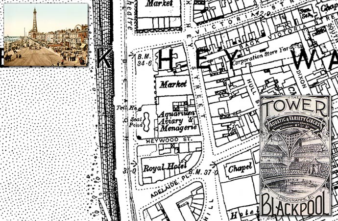
Botchergate, Carlisle (MAP: OS Town Plans 1:500 – published in 1865)

vertical-pillarbox

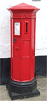
Thirteen years after Sir Rowland Hill, Secretary of the Post Office, introduced the Penny Post that the first mainland Pillar Box was erected in Botchergate, Carlisle in 1853.

The advent of the British wayside letter box can be traced to Sir Rowland Hill and his Surveyor for the Western District, and noted novelist, Anthony Trollope (known for The Warden, Barchester Towers and the Palliser novels).

Before 1853 it was customary to take outgoing mail to the nearest letter receiving house or post office, where the Royal Mail coach would stop to pick up and set down mail and passengers. People would take their letters in person, or in some areas they could await the appearance of the Bellman. The Bellman wore a uniform and walked the streets collecting letters from the public while ringing a bell to attract attention.

In 1852 Anthony Trollope was sent by Rowland Hill to the Channel Islands to ascertain what could be done about the problem of collecting the mail on the islands. To post a letter in Jersey or Guernsey, the post had to be taken down to the quayside and handed to the Master of the Royal Mail steamer in person. This was a somewhat inconvenient practice, subject as it was to the uncertainties of weather and tides.

Trollope’s recommendation back to Hill was to employ a device he had probably seen in Paris: a “letter-receiving pillar”. The first pillar boxes was brought into public use on Jersey in late November 1852 and they were an instant success.

By the next year the idea had spread to mainland Britain, with England’s first pillar box erected at the corner of Botchergate and South Street in Carlisle. In basic form all boxes were vertical cast iron ‘pillars’ with a small vertical slit to receive letters, but by 1857, after experimenting with various designs, horizontal, rather than vertical, slots were taken as a standard. The Committee responsible for the standardisation designed a very ornate box festooned with Grecian style-decoration but, in a major oversight, devoid of any posting aperture, which meant the slots were chiselled out of the cast iron by local craftsmen, usually destroying the look of the box.

Prior to 1859 colours varied until a bronze green colour was chosen as the new standard, which was to last until 1874. Initially it was thought that the green colour would be unobtrusive. Too unobtrusive, as it turned out — people kept either walking into them or past them. Red became the standard colour in 1874, although ten more years elapsed before every box in the UK had been repainted.

Find out about the history of your area. Visit Cassini Maps


Cassini Maps Sale – 25% OFF!

Cassini Quad Map

Last few days of this Special Offer! – 25% Off all maps (ends 30th Sept 2015)
Use the code C-SUN15 to claim your Discount.

Simply enter the code when prompted during checkout. P&P applies as normal.
Offer applies to all maps available on www.cassinimaps.co.uk
Including our Quad maps (4 maps of the same location but from diferent time periods) as shown above.

New! – Cassini brings you Ordnance Survey’s most detailed historical mapping.
Cassini’s Town Plan mapping is the most detailed historical Ordnance Survey mapping available. Easy to find and download.
Town Plan Map

Maps published from the mid 1800’s to the 1920’s
• Instant downloads only £9.99 (RRP:£14.99)
• Ideal for Family History research
• Choose maps from 468 available Towns
• Amazing detail – 1:500, 1:528 and 1:1056 scales (dependent on location)

These maps were published for larger towns and cities at scales of 1:500, (c.10′ to 1 mile), 1:528 (exactly 10′ to 1 mile) and 1:1056 (5′ to 1 mile) from the mid 1800’s onwards. An immense amount of detail is shown, down to every lamp-post and every pillar-box, even paths, trees and sheds in peoples gardens. For those who are particularly interested in local history and genealogy, the town plans are essential research tool.

Find maps of your area on the Cassini Maps website Town Plan Maps

Zeppelin Raids – The birth of the Blitz.

St. Peter’s Plain, Great Yarmouth (MAP: OS Town Plans 1:500 – published in 1885)
Zeppelins over Great Yarmouth

2015 marks the 100th anniversary of the first Zeppelin air raids on the UK.

On the 19th January 1915 two Zeppelin naval airships, 190 metres long, were heading for Humberside but were blown further down the east coast by strong gusts. They were forced to switch their attacks to the coastal towns of Norfolk. Zeppelins L3 and L4 crossed the coast of East Anglia, north of Great Yarmouth. Zeppelin L4 flew on towards Kings Lynn while Zeppelin L3, piloted by Kaptain Lt. Hans Fritz, turned back towards Great Yarmouth.

The first bomb dropped by L3 was an incendiary which landed in a waterlogged field in Little Ormesby, the second fell on a lawn in Albermarle Road near Wellesley. The first explosive to be dropped struck the pavement in Crown Road, but failed to explode, but the fourth and most destructive of the bombs to land on Great Yarmouth fell in St Peter’s Plain and burst with devasstating effect instantly killing Martha Taylor and shoemaker Sam Smith, while two more people were injured. By the end of the night two more people had been killed in Kings Lynn.

By the end of the First World War Zeppelin’s and other airships made about 51 bombing raids on England, killing 557 and injured another 1,358 people. More than 5,000 bombs were dropped on towns across Britain, causing £1.5 million in damage. 84 airships in all took part, of which 30 were lost, either shot down or lost in accidents. At the start of the war there were few weapons capable of combatting the Zeppelin threat. Conventional bullets would pass harmlessly through the aluminium frame and gas-bags. Not until the invention of incendiary bullets was there an effective way of bringing the Zeppelins down.

This first raid marked a change in the face of conflict, with the bombings serving as a forewarning of what was to come during the Blitz in the Second World War.

Find out about the history of your area. Visit Cassini Maps

14,659 Parish Maps from England and Wales!

OPM2
Cassini – Old Parish Maps

RRP £12.99 Introductory offer – Now only £4.99
Offer ends 31/10/2014

(Sample)  (Keys & Legends)

Cassini Maps has created these Old Parish Maps an essential resource for family history researchers, genealogists and historians. As parish boundaries have changed over time, its essential to know where your ancestors lived and to understand the landscape that shaped their lives.

• Parish Maps provide a direct link to Census and Parish Records.
• Download the PDF to view on screen and print at home.
• Parish boundaries as they were in 1911.
• Detailed Ordnance Survey mapping published between 1880 – 1910.
• Downloadable PDFs of English and Welsh Parishes.
• Scale: Street-level mapping – 1:10,000 (originally 1:10,560).

Visit Cassini’s Old Parish Maps page

14,659 individual historical Parishes Maps are now available to download and to print at home. These maps provide a vital link to Parish Records and show in great detail the historical Parishes in which your ancestors lived and worked. Each maps is taken from the Ordnance Survey County Series 1:10,560 maps from the cusp of 19th and 20th centuries and show the Historical Parish Boundary as recorded at the time of the 1911 census.

About the Maps
The origins of the six-inch to the mile maps (1:10,560) date back to 1824 when this scale was adopted for a survey of Ireland. By 1840 it had been decided to extend the project to Great Britain. To conduct a survey at such a scale, every corner of the country, including private property, would need to be visited. The following year, the Survey Act was passed which gave surveyors the right to enter any land for the purposes of carrying out their duties. It also specified the types of boundaries that the new maps were to display (down to parish level).

Cassini has reproduced County Series Parish Maps for the whole of England and Wales. This involved combining more than one original sheet to give an appropriate area of coverage. In the process, the maps have been digitally enhanced and enlarged slightly to 1:10,000 to bring them into line with more recent maps at this metric scale.

Cassini Maps

Map of the month – Blackpool before the tower 1891

Blackpool

Blackpool (Ordnance Survey County Series 1:1,056 – Surveyed  C.1891, published in 1893)

For centuries Blackpool was a small hamlet by the sea. Its name stems from a historic drainage channel that ran over a peat bog, discharging discoloured water into the Irish Sea, which formed a black pool (on the other side of the sea, the name “Dublin” (Dubh Linn) is derived from the Irish for “black pool”).

By the middle of the 18th century, the practice of bathing in the sea to cure diseases was becoming fashionable among the wealthier classes, and visitors began making the trek to Blackpool for that purpose. The 1801 census records the town’s population at only 473, but by 1851 the population had risen to over 2,500.  However, Blackpool only grew into a substantial town when the railway was built connecting it to the industrial towns of the north. The first railway in the area opened in 1840 but it only ran as far as Poulton. In 1846 a branch line was built from Poulton to Blackpool, making it much easier and cheaper for visitors to reach the coast.

Blackpool Tower was built between 1891 and 1894, but before the tower visitors flocked to Dr. Cocker’s Aquarium, Aviary and Menagerie, which had existed on the site since 1873. It was kept open to earn revenue while the tower building went up around it, and then became one of the tower’s major attractions. It housed 57 different species of fresh water and salt water fish and the largest tank held 32,000 litres of salt water. The menagerie and aviary, one of the finest collections in the country, included lions, tigers, and polar bears.

The Blackpool Tower Company bought the Aquarium on Central Promenade in 1890 with the intention of building a replica Eiffel Tower on the site. Two Lancashire architects, James Maxwell and Charles Tuke, designed the Tower and oversaw the laying of its foundation stone, on 29 September 1891

When the tower opened on 14 May 1894, 3,000 customers took the first rides to the top. Tourists paid sixpence for admission, sixpence more for a ride in the lifts to the top (the option was 563 steps from the roof of the tower building to the flagpole at the top) and a further sixpence for entry to the circus.

The Tower Circus, which is positioned at the base of the tower between its four legs, first opened to the public on 14 May 1894 and has not missed a season since. The circus ring can be lowered into a pool of water that holds 42,000 gallons at a depth of up to 4 ft 6 inches, which allows for Grand Finales with Dancing Fountains. The Tower Circus is one of only four venues left in the world that can do this.

The tower was not painted properly during the first thirty years and became corroded, leading to discussions about its demolishing. However it was decided to rebuild it instead, and between 1921 and 1924 all of the steelwork in the structure of the tower was replaced and renewed.

With attractions like these, the building of the Promenade, the three Piers (North, Central and South), tram rides and the famous Illuminations, Blackpool continued to grow until by 1951 the population had grown to 147,000. Today the population of Blackpool has settled back to a healthy 142,000.

If you have an interesting story and would like to see a historical map of your area then why not let us know by emailing us.

Map of the month – Euston Station

Euston Station
Euston Station, London (Town Plan 1:1,056)

Euston was the first inter-city railway station in central London, opened on 20 July 1837 as the terminus of the London and Birmingham Railway.

The site was selected in the early 1830s by George and Robert Stephenson, engineers of the London and Birmingham Railway. The area was then mostly farmland at the edge of the expanding city of London. The station was named after Euston Hall in Suffolk, the ancestral home of the Dukes of Grafton, who were the main landowners in the area.

Before Euston was built the trains from Birmingham had an unsatisfactory endpoint at Chalk Farm, built in 1833. It was George Stephenson who planned the original station at Euston Grove with just two platforms, one for arrivals, one departures, sheltered beneath a massive wrought-iron roof. The building was designed by Philip Hardwick, fronted by a 72’ high porticot. This portico acquired the name Euston Arch.

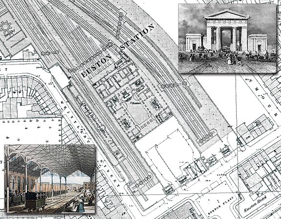
There was a notable engineering oddity about Euston from its opening on July 20 1837: because Lord Southampton, master of the Quorn Hunt, Conservative grandee, and a major landowner locally, objected to the potential noise and dirt, no locomotives were allowed between Euston and Camden Town. Instead trains were pulled from the terminus to Camden by a cable device until 1844, when engines were at last allowed.

The station grew rapidly over the following years as traffic increased. It was greatly expanded in the 1840s, with the opening in 1849 of the spectacular Great Hall, designed by Hardwick’s son Philip Charles Hardwick in classical style. It was 126 ft long, 61 ft wide and 64 ft high, with a coffered ceiling and a sweeping double flight of stairs leading to offices at its northern end.

The pioneers who established the railway network built Euston Arch, the massive Doric portico, outside the first terminus in London, Euston Station; in the 1960s their ancestors knocked it down in what many consider to be an act of cultural vandalism. Perhaps there is hope for this generation as a campaign now exists to have the Euston Arch restored.

If you have an interesting story and would like to see a historical map of your area then why not let us know by emailing us.

The Scriptorium & the birth of the OED.

Main Map: Ordnance Survey County Series 1:2500 – 1886
(Frederick Furnivall on the left, James Murray top right)
Oxford English Dictionary
In 1884 the first section of The Oxford English Dictionary was published.

Work on the project had begun in 1857, when members of the Philological Society agreed that existing dictionaries of the English language were far from adequate. Three members of that learned society were the great drivers of the idea in its early days: Herbert Coleridge; Frederick Furnivall; and Richard Trench. In June 1857, they formed an “Unregistered Words Committee” to search for unlisted and undefined words lacking in current dictionaries.

After Richard Trench’s appointment as Dean of Westminster and the death of Herbert Coleridge, Furnivall became editor. Furnivall believed that since many printed texts from earlier centuries were not readily available, it would be impossible for volunteers to locate the quotations that the dictionary needed. As a result, Furnivall founded the Early English Text Society in 1864 and the Chaucer Society in 1868 to publish old manuscripts. Furnivall’s preparatory efforts, which lasted 21 years, provided numerous texts for the use and enjoyment of the general public, but did not actually involve compiling a dictionary.

In the 1870s, Furnivall approached James Murray, who accepted the post of editor.
Murray started the project, working in a corrugated iron outbuilding, the “Scriptorium”, which was lined with wooden planks, book shelves, and 1,029 pigeon-holes for the quotation slips.
Through newspapers Murray appealed for readers who would report “as many quotations as you can for ordinary words” and for words that were “rare, obsolete, old-fashioned, new, peculiar or used in a peculiar way”.  1,000 quotation slips arrived daily to the Scriptorium, and by 1882, there were 3,500,000.

In 1878, Oxford University Press agreed with Murray to proceed with publishing the massive project; the agreement was formalized the following year. The dictionary project finally had a publisher 20 years after the idea was conceived. It would be another 50 years before the entire dictionary was complete.

In spite of this involvement, the work was not to be known as The Oxford English Dictionary until 1895, its working title until then having been the wordier ‘A New English Dictionary on Historical Principles; Founded Mainly on the Material Collected by The Philological Society’.

The first dictionary collection was published on 1 February 1884—twenty-three years after Coleridge’s sample pages.  the 352-page volume, words from A to Ant, was finally on sale for 12s.6d

The first fully bound and complete edition of the work finally appeared in 1928, long after the three men whose original vision it was had died.

If you have an interesting story and would like to see a historical map of your area then why not let us know by emailing us. 

Gretna Green, or is it Headless Cross?

Main Map: Ordnance Survey County Series 1:2500 – 1899*
Gretna Green
Gretna Green – the village famous for runaway weddings.

Gretna Green is a village in the south of Scotland famous for runaway weddings, hosting over 5,000 weddings each year in the Gretna/Gretna Green area, and according to the BBC, one in every six Scottish weddings.  It is situated in Dumfries and Galloway, near the mouth of the River Esk and was historically the first village in Scotland, following the old coaching route from London to Edinburgh.

It has been reported that Gretna’s famous “runaway marriages” began in 1754 when Lord Hardwicke’s Marriage Act  became law in England. Under the Act, if a parent of a person under the age of 21 objected, they could prevent the marriage going ahead. The new law tightened up the requirements for marrying in England and Wales but did not apply in Scotland, where it was possible for boys to marry at 14 and girls at 12 with or without parental consent. By the 1770s, with the construction of a toll road passing through the hitherto obscure village of Graitney (Gretna), that Gretna Green became the first easily reachable village over the Scottish border. The Old Blacksmith’s Shop, built around 1712, and Gretna Hall Blacksmith’s Shop (1710) became the focal points for the marriage trade. The Old Blacksmith’s opened to the public as a visitor attraction as early as 1887.

The local blacksmith and his anvil have become the lasting symbols of Gretna Green weddings. Scottish law allowed for “irregular marriages”, meaning that if a declaration was made before two witnesses, almost anybody had the authority to conduct the marriage ceremony.
To seal the marriage the blacksmith would bring down his hammer upon the anvil. The ringing sound heard throughout the village would signify that another couple had been joined in marriage.
The blacksmiths in Gretna became known as “anvil priests”, culminating with Richard Rennison, who performed 5,147 ceremonies.

Since 1929, both parties in Scotland have had to be at least 16 years old, but they still may marry without parental consent. In England and Wales, the age for marriage is now 16 with parental consent and 18 without.

If you have an interesting story and would like to see a historical map of your area then why not let us know by emailing us.

Map of the week – Lord’s Cricket Ground

Lords - The Home of Cricket
Map: Stanford’s London Street Map – 1891

The home of cricket.
Lord’s Cricket Ground, is in St John’s Wood, London. Rather than referring to any connection with the peerage, Lord’s is actually named after its founder, Thomas Lord  (1755 – 1832), an English professional cricketer who played first-class cricket from 1787 to 1802. It is owned by Marylebone Cricket Club (MCC) and is the home of Middlesex County Cricket Club. Lord’s is also widely referred to as the “home of cricket” and is home to the world’s oldest sporting museum.

Lord’s today is not on its original site, being the third of three grounds that Lord established between 1787 and 1814. His first ground, now referred to as Lord’s Old Ground, was where Dorset Square now stands next to Marylebone Station. His second ground, Lord’s Middle Ground, was used from 1811 to 1813 before being abandoned to make way for the construction of the Regent’s Canal. The present Lord’s ground is about 250 yards north-west of the site of the Middle Ground. Next door to the ground can be seen the Nursery still referred to in cricketing circles as the Nursery End of the ground.

Some facts about Lord’s:
The earliest known match played on the current Lord’s Cricket Ground was Marylebone Cricket Club v Hertfordshire on 22 June 1814.
1866-67 Freehold of the Ground purchased for £18,333 6s 8d.
1868 Aboriginal cricketers become the first Australian team to play cricket at Lord’s
The main survivor of the Victorian era is The Pavilion with its famous Long Room.
Lord’s is also the home of the MCC Museum, which is the oldest sports museum in the world, and contains the world’s most celebrated collection of cricket memorabilia, including The Ashes, which again will be the centre of this summers anticipated clash with the current Australian side.

If you have an interesting story and would like to see a historical map of your area then why not let us know by emailing us.

Blood, The Tower and the Crown

Colonel Thomas Blood

Map: Ordnance Survey 1:1056 County Series 1871 – Interior of The Tower Of London

Colonel Blood and the theft of the Crown Jewels.

Colonel Thomas Blood (1618 – 1680) was of Anglo-Irish origins, born in County Clare, in what was then the Kingdom of Ireland.Following the Restoration of King Charles II, the 1662 Act of Settlement cancelled a grant of land allocated to Blood by Cromwell, as a reward for his services during the Civil War, and brought Blood to financial ruin. Blood sought to unite the remaining Cromwellians in Ireland with the aim of insurrection.

A plot to storm Dublin Castle, overturn the government, and kidnap the Duke of Ormonde (The Lord Lieutenant of Ireland), was foiled and Blood fled to the Netherlands. A few of Blood’s collaborators were captured and subsequently executed. As a result, historians have speculated that Blood swore vengeance. Blood returned to England in 1670 where, six months later he made his notorious attempt to steal the Crown Jewels.In 1671, he visited the Tower of London, dressed as a parson and accompanied by a female companion pretending to be his wife. While viewing the Crown Jewels (made possible by the payment of a fee to the custodian), Blood’s companion feigned stomach pains and begged the Master of the Jewel House, 77-year-old Talbot Edwards, for help. Edwards’ wife invited them upstairs to their living quarters to recover, after which Blood and his ‘wife’ thanked the Edwards and left.

Over the following days Blood returned to the Tower to visit the Edwards and presented Mrs. Edwards with a present of white gloves as a gesture of thanks. As Blood became friendly with the family, he proposed that a fictitious nephew of his should marry the Edwards’ daughter, a marriage that he said would make her eligible for an income of several hundred pounds.

By the 9th May 1671 Blood, now accepted as a potential moneyed in-law, convinced Edwards to show the jewels to himself, his supposed nephew, and two of his friends. On entering the Jewel House a cloak was thrown over Edwards, who was then struck with a mallet, bound, gagged and stabbed. Blood then used the mallet to flatten the ‘St. Edward’s Crown’ so that he could hide it beneath his clerical coat. Blood’s accomplice, his brother-in-law, used a file to saw the ‘Sceptre with the Cross’ in two to enable it to fit into a bag, while the third man, Parrot, stuffed the ‘Sovereign’s Orb’ down his trousers.

Fortuitously Edwards’ son was returning from military service and stumbled upon the scene. At the same time Edwards managed to free the gag and raised the alarm shouting, “Treason! Murder! The crown is stolen!”  Blood and his gang fled to their horses. They dropped the crown and the sceptre and fired at the warders who attempted to stop them. They were finally chased down and captured by Captain Beckman, brother-in-law of the younger Edwards.

Following his capture Blood refused to answer to anyone but the king and was consequently taken to the palace. To the disgust of Lord Ormonde, Blood was not only pardoned, but also given land in Ireland worth £500 a year. Following his pardon Blood became a familiar figure around London and made frequent appearances at Court, before he died on August 24 1680 at his home in Bowling Alley, Westminster.

If you have an interesting story and would like to see a historical map of your area then why not let us know by emailing us.
.
.