Zeppelin Raids – The birth of the Blitz.

St. Peter’s Plain, Great Yarmouth (MAP: OS Town Plans 1:500 – published in 1885)
Zeppelins over Great Yarmouth

2015 marks the 100th anniversary of the first Zeppelin air raids on the UK.

On the 19th January 1915 two Zeppelin naval airships, 190 metres long, were heading for Humberside but were blown further down the east coast by strong gusts. They were forced to switch their attacks to the coastal towns of Norfolk. Zeppelins L3 and L4 crossed the coast of East Anglia, north of Great Yarmouth. Zeppelin L4 flew on towards Kings Lynn while Zeppelin L3, piloted by Kaptain Lt. Hans Fritz, turned back towards Great Yarmouth.

The first bomb dropped by L3 was an incendiary which landed in a waterlogged field in Little Ormesby, the second fell on a lawn in Albermarle Road near Wellesley. The first explosive to be dropped struck the pavement in Crown Road, but failed to explode, but the fourth and most destructive of the bombs to land on Great Yarmouth fell in St Peter’s Plain and burst with devasstating effect instantly killing Martha Taylor and shoemaker Sam Smith, while two more people were injured. By the end of the night two more people had been killed in Kings Lynn.

By the end of the First World War Zeppelin’s and other airships made about 51 bombing raids on England, killing 557 and injured another 1,358 people. More than 5,000 bombs were dropped on towns across Britain, causing £1.5 million in damage. 84 airships in all took part, of which 30 were lost, either shot down or lost in accidents. At the start of the war there were few weapons capable of combatting the Zeppelin threat. Conventional bullets would pass harmlessly through the aluminium frame and gas-bags. Not until the invention of incendiary bullets was there an effective way of bringing the Zeppelins down.

This first raid marked a change in the face of conflict, with the bombings serving as a forewarning of what was to come during the Blitz in the Second World War.

Find out about the history of your area. Visit Cassini Maps

Map of the month – Port Richborough

Port Richborough
Port Richborough, Kent
(Map; Popular Edition 1920. Original scale 1:63,360 or One Inch to the Mile)

Situated amid the East Kent marshes Richborough is perhaps the most symbolically important of Roman sites in Britain. It is thought by many that the four invading Legions under Aulus Plautius assembled in Richborough after landing in Britain during the Claudian Invasion of A.D. 43.

Fast forward nearly 1900 years and troops were heading back into Europe. In January 1916 during the height of WWI, it was decided to develop Richborough as a depot and base for inland water transport to service the troops. At this time Richborough consisted of a short length of quay suitable for barges, and one solitary dwelling house.

By 1918, the enormous feat had been completed of transforming Richborough  into a large and well- equipped seaport, of 2,000 acres, complete with all services and capable of handling 30,000 tons of traffic per week. 2,300 ft of new wharf was built for the cross-channel barge service, in which, at the end of the war, 242 barges were employed, including ten of 1,000 ton capacity.

Among the new ports features was what we we today call a “roll-on, roll-off” ferry – for railway trains. Among the many tons moved from Richborough were complete trains carrying tanks, direct from the factories to the British army on the front line. The use of train-ferries greatly reduced the amount of labour required in the transport of these items. It took only 30 to 40 minutes to load or unload the 54 railway wagons and fifty or sixty motor vehicles that could be carried by these train-ferries. An analysis done at the time found that to transport 1,000 tons of war material from the point of manufacture to the front by conventional shipping means involved the use of 1,500 labourers, whereas when using train-ferries that number decreased to around 100 labourers.

So well camouflaged was the port, that it became known as the Mystery Harbour. All port buildings were one-story, their walls and roofs were painted to match the general background of a low-lying area. B Type War BusThe military secret was so strictly and carefully observed by the British, that the existence of the port had been unknown to the Germans during the whole war; the port was often overflown by the aircraft heading to drop bombs on London, where the bombs were striking civilians, but no bombs were ever dropped on Richborough.
After the signing of the Armistice on 11 November 1918, train ferries were used extensively for the return of material from the Front. Indeed according to war office statistics, a greater tonnage of material was transported by train ferry at Richborough in 1919 than in 1918. The returning train ferries had space for motor transport as well as railway rolling stock, thousands of lorries, motor cars and “B Type” buses also returned via this route. It’s a little known fact that buses transported troops to and from the Front Line and were put to use as ambulances and even mobile pigeon lofts. Nearly 1,200 London General Omnibus Company vehicles went on war service, most to France and Belgium, with some travelling as far afield as Egypt.

If you have an interesting story and would like to see a historical map of your area then why not let us know by emailing us.

Map of the month – The lost village of Imber

Lost Village of Imber

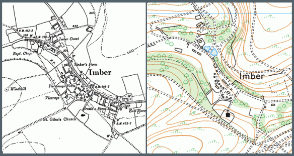
The lost village of Imber, Wiltshire (County series 1:10,000)

Described by Ella Noyes in the 1890’s, Imber was “one straggling street of old cottages and farmsteads winding along the hollow under the sheltering elms.” The village of Imber had been a remote village nestled in a small valley on Salisbury Plain in Wiltshire. It had for centuries made the most of its secluded existence by surviving largely unscathed by both civil unrest and pestilence that had from time to time existed elsewhere in England.

It was later in the 1890’s that its fortunes started to change with the arrival of the Army on Salisbury Plain. The War Office concluded its search for a large training environment with the purchase of over 40,000 acres of land on the east of the plain.

With the advent of WW1, training increased significantly around Imber with the villagers suffering virtual imprisonment as the surrounding countryside was shelled.

The village struggled to maintain its self-sufficiency on the cratered landscape it had sought to farm in the post war years and its decline continued until 1943, when, with the village now in the centre of the military’s western ranges, the inhabitants were given 46 days to leave.

There is little of the original village remaining today and nearly half of the standing structures were built by the army.

If you have an interesting story and would like to see a historical map of your area then why not let us know by emailing us.